You are here: Home > Network List > UW - Pacific Northwest Regional Seismic Network Stations List
> Station IRON Circle Bar Ranch, Crane, OR, USA > Earthquake Result Viewer
IRON Circle Bar Ranch, Crane, OR, USA - Earthquake Result Viewer
| Earthquake location: |
Near Coast Of Guerrero, Mexico |
| Earthquake latitude/longitude: |
16.5/-98.2 |
| Earthquake time(UTC): |
2012/03/20 (080) 18:02:47 GMT |
| Earthquake Depth: |
20 km |
| Earthquake Magnitude: |
6.6 MB, 7.6 MS, 7.4 MW, 7.4 MW |
| Earthquake Catalog/Contributor: |
WHDF/NEIC |
|
| Network: |
UW Pacific Northwest Regional Seismic Network |
| Station: |
IRON Circle Bar Ranch, Crane, OR, USA |
| Lat/Lon: |
43.36 N/118.47 W |
| Elevation: |
1229 m |
|
| Distance: |
31.8 deg |
| Az: |
331.419 deg |
| Baz: |
141.004 deg |
| Ray Param: |
0.07888705 |
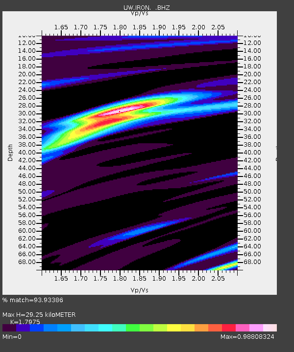
| Estimated Moho Depth: |
29.25 km |
| Estimated Crust Vp/Vs: |
1.80 |
| Assumed Crust Vp: |
6.279 km/s |
| Estimated Crust Vs: |
3.493 km/s |
| Estimated Crust Poisson's Ratio: |
0.28 |
|
| Radial Match: |
93.93386 % |
| Radial Bump: |
209 |
| Transverse Match: |
84.749435 % |
| Transverse Bump: |
400 |
| SOD ConfigId: |
440406 |
| Insert Time: |
2012-06-03 02:43:19.812 +0000 |
| GWidth: |
2.5 |
| Max Bumps: |
400 |
| Tol: |
0.001 |
|
Signal To Noise
| Channel | StoN | STA | LTA |
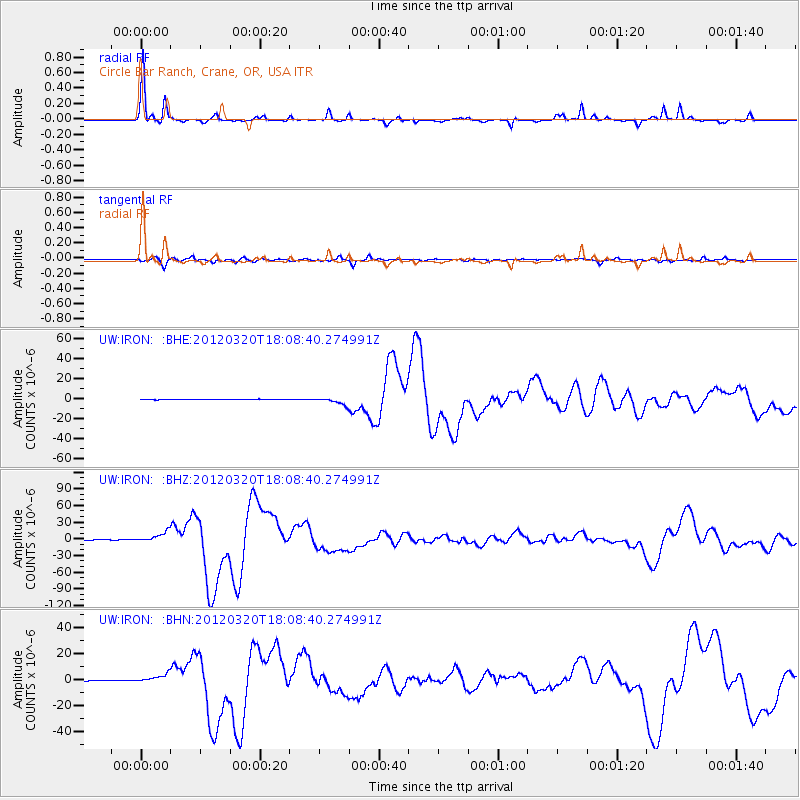
| UW:IRON: :BHZ:20120320T18:08:40.274991Z | 28.711073 | 9.076759E-6 | 3.1614138E-7 |
| UW:IRON: :BHN:20120320T18:08:40.274991Z | 10.034331 | 3.2155665E-6 | 3.2045645E-7 |
| UW:IRON: :BHE:20120320T18:08:40.274991Z | 16.893764 | 3.6092833E-6 | 2.1364589E-7 |
| Arrivals |
| Ps | 4.0 SECOND |
| PpPs | 12 SECOND |
| PsPs/PpSs | 16 SECOND |


