You are here: Home > Network List > UW - Pacific Northwest Regional Seismic Network Stations List
> Station KENT Carlson Farm, Grass Valley, OR, USA > Earthquake Result Viewer
KENT Carlson Farm, Grass Valley, OR, USA - Earthquake Result Viewer
| Earthquake location: |
Near Coast Of Guerrero, Mexico |
| Earthquake latitude/longitude: |
16.5/-98.2 |
| Earthquake time(UTC): |
2012/03/20 (080) 18:02:47 GMT |
| Earthquake Depth: |
20 km |
| Earthquake Magnitude: |
6.6 MB, 7.6 MS, 7.4 MW, 7.4 MW |
| Earthquake Catalog/Contributor: |
WHDF/NEIC |
|
| Network: |
UW Pacific Northwest Regional Seismic Network |
| Station: |
KENT Carlson Farm, Grass Valley, OR, USA |
| Lat/Lon: |
45.24 N/120.64 W |
| Elevation: |
780 m |
|
| Distance: |
34.3 deg |
| Az: |
331.431 deg |
| Baz: |
139.511 deg |
| Ray Param: |
0.0778018 |
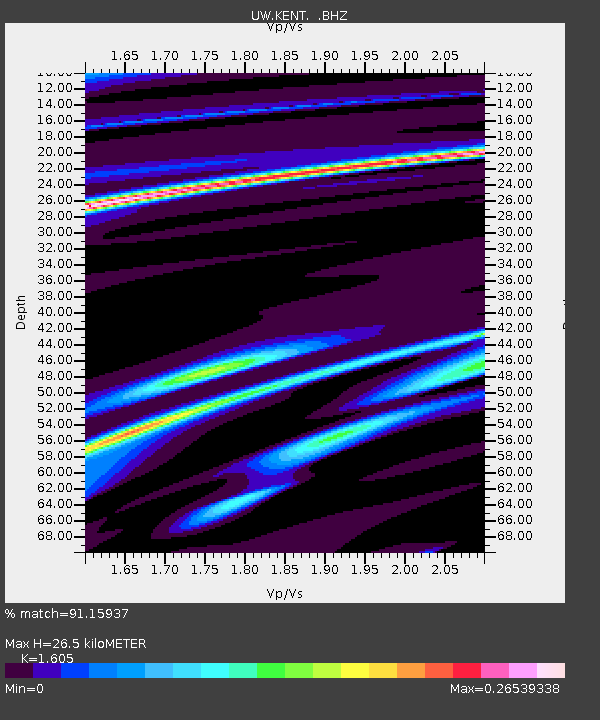
| Estimated Moho Depth: |
26.5 km |
| Estimated Crust Vp/Vs: |
1.61 |
| Assumed Crust Vp: |
6.597 km/s |
| Estimated Crust Vs: |
4.111 km/s |
| Estimated Crust Poisson's Ratio: |
0.18 |
|
| Radial Match: |
91.15937 % |
| Radial Bump: |
174 |
| Transverse Match: |
91.19694 % |
| Transverse Bump: |
194 |
| SOD ConfigId: |
440406 |
| Insert Time: |
2012-06-03 02:43:21.745 +0000 |
| GWidth: |
2.5 |
| Max Bumps: |
400 |
| Tol: |
0.001 |
|
Signal To Noise
| Channel | StoN | STA | LTA |
| UW:KENT: :BHZ:20120320T18:09:01.475004Z | 11.879876 | 9.46098E-6 | 7.9638716E-7 |
| UW:KENT: :BHN:20120320T18:09:01.475004Z | 1.526554 | 1.2505181E-8 | 8.191771E-9 |
| UW:KENT: :BHE:20120320T18:09:01.475004Z | 5.1819515 | 3.962748E-6 | 7.647211E-7 |
| Arrivals |
| Ps | 2.7 SECOND |
| PpPs | 9.6 SECOND |
| PsPs/PpSs | 12 SECOND |


