You are here: Home > Network List > AK - Alaska Regional Network Stations List
> Station FALS False Pass > Earthquake Result Viewer
FALS False Pass - Earthquake Result Viewer
| Earthquake location: |
New Guinea, Papua New Guinea |
| Earthquake latitude/longitude: |
-6.2/146.0 |
| Earthquake time(UTC): |
2012/03/21 (081) 22:15:06 GMT |
| Earthquake Depth: |
118 km |
| Earthquake Magnitude: |
6.3 MB, 6.6 MW, 6.6 MW |
| Earthquake Catalog/Contributor: |
WHDF/NEIC |
|
| Network: |
AK Alaska Regional Network |
| Station: |
FALS False Pass |
| Lat/Lon: |
54.86 N/163.42 W |
| Elevation: |
46 m |
|
| Distance: |
73.9 deg |
| Az: |
27.718 deg |
| Baz: |
233.103 deg |
| Ray Param: |
0.05237062 |
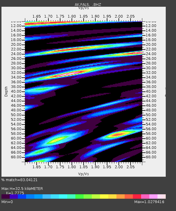
| Estimated Moho Depth: |
32.5 km |
| Estimated Crust Vp/Vs: |
1.78 |
| Assumed Crust Vp: |
5.989 km/s |
| Estimated Crust Vs: |
3.369 km/s |
| Estimated Crust Poisson's Ratio: |
0.27 |
|
| Radial Match: |
83.04121 % |
| Radial Bump: |
400 |
| Transverse Match: |
78.620415 % |
| Transverse Bump: |
400 |
| SOD ConfigId: |
440406 |
| Insert Time: |
2012-06-03 02:50:27.053 +0000 |
| GWidth: |
2.5 |
| Max Bumps: |
400 |
| Tol: |
0.001 |
|

Signal To Noise
| Channel | StoN | STA | LTA |
| AK:FALS: :BHZ:20120321T22:25:57.588008Z | 11.436284 | 4.0376467E-6 | 3.5305584E-7 |
| AK:FALS: :BHN:20120321T22:25:57.588008Z | 1.8585539 | 9.698333E-7 | 5.218215E-7 |
| AK:FALS: :BHE:20120321T22:25:57.588008Z | 2.3397849 | 1.5844088E-6 | 6.7716E-7 |
| Arrivals |
| Ps | 4.3 SECOND |
| PpPs | 15 SECOND |
| PsPs/PpSs | 19 SECOND |


