You are here: Home > Network List > AU - Australian Seismological Centre Stations List
> Station XMI Christmas Island Airport > Earthquake Result Viewer
XMI Christmas Island Airport - Earthquake Result Viewer
| Earthquake location: |
New Guinea, Papua New Guinea |
| Earthquake latitude/longitude: |
-6.2/146.0 |
| Earthquake time(UTC): |
2012/03/21 (081) 22:15:06 GMT |
| Earthquake Depth: |
118 km |
| Earthquake Magnitude: |
6.3 MB, 6.6 MW, 6.6 MW |
| Earthquake Catalog/Contributor: |
WHDF/NEIC |
|
| Network: |
AU Australian Seismological Centre |
| Station: |
XMI Christmas Island Airport |
| Lat/Lon: |
10.45 S/105.69 E |
| Elevation: |
252 m |
|
| Distance: |
40.0 deg |
| Az: |
261.23 deg |
| Baz: |
87.286 deg |
| Ray Param: |
0.07423023 |
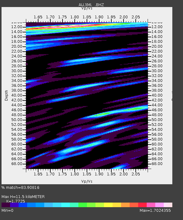
| Estimated Moho Depth: |
11.5 km |
| Estimated Crust Vp/Vs: |
1.77 |
| Assumed Crust Vp: |
4.157 km/s |
| Estimated Crust Vs: |
2.345 km/s |
| Estimated Crust Poisson's Ratio: |
0.27 |
|
| Radial Match: |
83.90816 % |
| Radial Bump: |
400 |
| Transverse Match: |
78.73922 % |
| Transverse Bump: |
400 |
| SOD ConfigId: |
440406 |
| Insert Time: |
2012-06-03 02:52:48.277 +0000 |
| GWidth: |
2.5 |
| Max Bumps: |
400 |
| Tol: |
0.001 |
|

Signal To Noise
| Channel | StoN | STA | LTA |
| AU:XMI: :BHZ:20120321T22:21:59.24499Z | 8.292947 | 7.3465235E-6 | 8.8587615E-7 |
| AU:XMI: :BHN:20120321T22:21:59.24499Z | 0.7885134 | 8.407669E-7 | 1.0662684E-6 |
| AU:XMI: :BHE:20120321T22:21:59.24499Z | 3.7362597 | 3.2697153E-6 | 8.751307E-7 |
| Arrivals |
| Ps | 2.2 SECOND |
| PpPs | 7.5 SECOND |
| PsPs/PpSs | 9.7 SECOND |


