You are here: Home > Network List > IC - New China Digital Seismograph Network Stations List
> Station WMQ Urumqi, Xinjiang Province, China > Earthquake Result Viewer
WMQ Urumqi, Xinjiang Province, China - Earthquake Result Viewer
| Earthquake location: |
New Guinea, Papua New Guinea |
| Earthquake latitude/longitude: |
-6.2/146.0 |
| Earthquake time(UTC): |
2012/03/21 (081) 22:15:06 GMT |
| Earthquake Depth: |
118 km |
| Earthquake Magnitude: |
6.3 MB, 6.6 MW, 6.6 MW |
| Earthquake Catalog/Contributor: |
WHDF/NEIC |
|
| Network: |
IC New China Digital Seismograph Network |
| Station: |
WMQ Urumqi, Xinjiang Province, China |
| Lat/Lon: |
43.81 N/87.70 E |
| Elevation: |
850 m |
|
| Distance: |
72.3 deg |
| Az: |
319.744 deg |
| Baz: |
117.448 deg |
| Ray Param: |
0.053464744 |
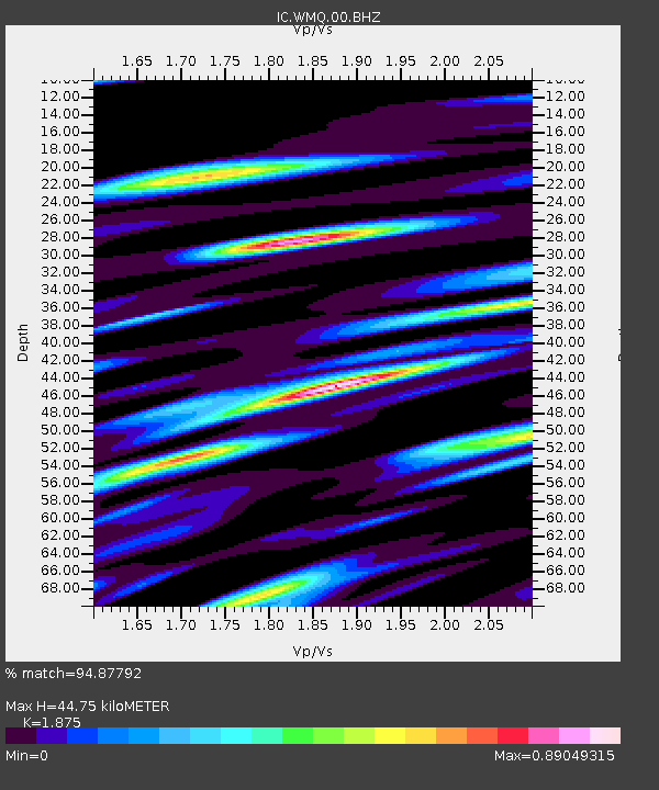
| Estimated Moho Depth: |
44.75 km |
| Estimated Crust Vp/Vs: |
1.88 |
| Assumed Crust Vp: |
6.242 km/s |
| Estimated Crust Vs: |
3.329 km/s |
| Estimated Crust Poisson's Ratio: |
0.30 |
|
| Radial Match: |
94.87792 % |
| Radial Bump: |
400 |
| Transverse Match: |
89.74503 % |
| Transverse Bump: |
400 |
| SOD ConfigId: |
440406 |
| Insert Time: |
2012-06-03 02:54:49.135 +0000 |
| GWidth: |
2.5 |
| Max Bumps: |
400 |
| Tol: |
0.001 |
|

Signal To Noise
| Channel | StoN | STA | LTA |
| IC:WMQ:00:BHZ:20120321T22:25:47.898005Z | 51.02063 | 5.218781E-6 | 1.0228767E-7 |
| IC:WMQ:00:BHN:20120321T22:25:47.898005Z | 29.111526 | 1.4712083E-6 | 5.053697E-8 |
| IC:WMQ:00:BHE:20120321T22:25:47.898005Z | 52.17239 | 2.060766E-6 | 3.9499167E-8 |
| Arrivals |
| Ps | 6.5 SECOND |
| PpPs | 20 SECOND |
| PsPs/PpSs | 26 SECOND |


