You are here: Home > Network List > G - GEOSCOPE Stations List
> Station INU Inuyama, Japan > Earthquake Result Viewer
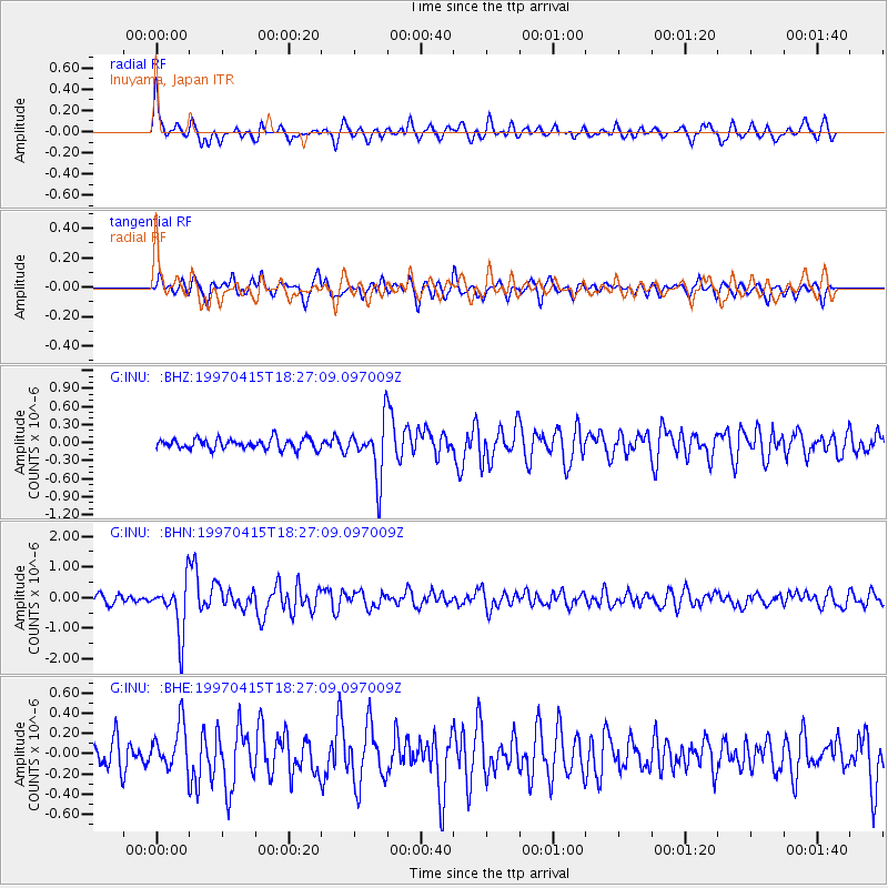
INU Inuyama, Japan - Earthquake Result Viewer
*The percent match for this event was below the threshold and hence no stack was calculated.
| Earthquake location: |
Southern Xinjiang, China |
| Earthquake latitude/longitude: |
39.6/77.0 |
| Earthquake time(UTC): |
1997/04/15 (105) 18:19:10 GMT |
| Earthquake Depth: |
23 km |
| Earthquake Magnitude: |
5.8 MS, 5.4 MB, 5.9 UNKNOWN, 5.7 MW |
| Earthquake Catalog/Contributor: |
WHDF/NEIC |
|
| Network: |
G GEOSCOPE |
| Station: |
INU Inuyama, Japan |
| Lat/Lon: |
35.35 N/137.03 E |
| Elevation: |
132 m |
|
| Distance: |
47.1 deg |
| Az: |
75.33 deg |
| Baz: |
293.953 deg |
| Ray Param: |
$rayparam |
*The percent match for this event was below the threshold and hence was not used in the summary stack. |
|
| Radial Match: |
76.45535 % |
| Radial Bump: |
400 |
| Transverse Match: |
66.11298 % |
| Transverse Bump: |
400 |
| SOD ConfigId: |
4480 |
| Insert Time: |
2010-02-26 23:23:34.160 +0000 |
| GWidth: |
2.5 |
| Max Bumps: |
400 |
| Tol: |
0.001 |
|
Signal To Noise
| Channel | StoN | STA | LTA |
| G:INU: :BHN:19970415T18:27:09.097009Z | 5.9006615 | 8.5777873E-7 | 1.4536992E-7 |
| G:INU: :BHE:19970415T18:27:09.097009Z | 1.6786071 | 2.2559374E-7 | 1.3439342E-7 |
| G:INU: :BHZ:19970415T18:27:09.097009Z | 5.2381005 | 4.5406296E-7 | 8.668466E-8 |
| Arrivals |
| Ps | |
| PpPs | |
| PsPs/PpSs | |


