You are here: Home > Network List > G - GEOSCOPE Stations List
> Station INU Inuyama, Japan > Earthquake Result Viewer
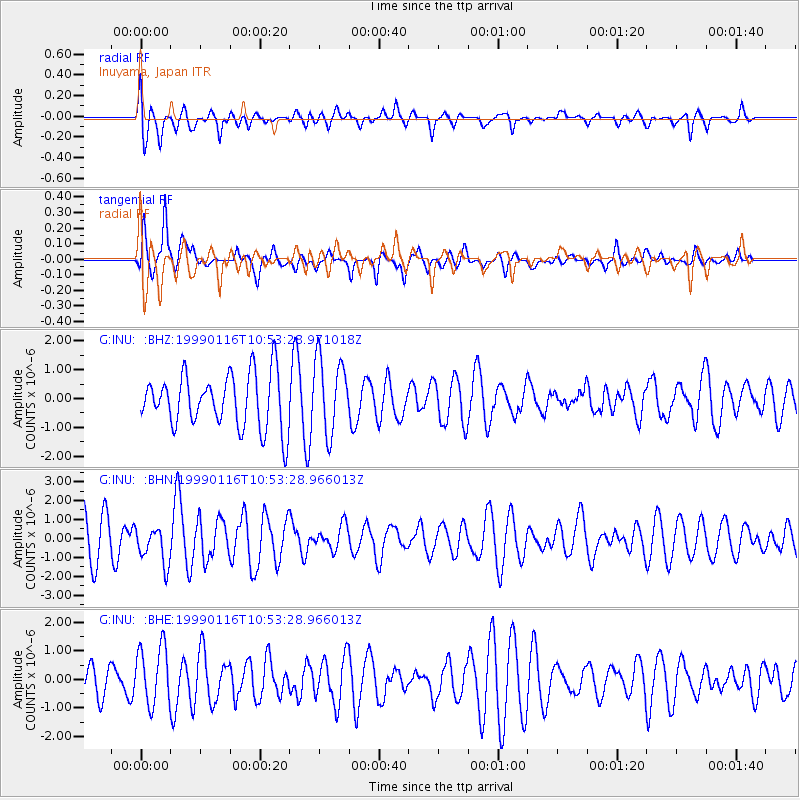
INU Inuyama, Japan - Earthquake Result Viewer
*The percent match for this event was below the threshold and hence no stack was calculated.
| Earthquake location: |
Gulf Of Alaska |
| Earthquake latitude/longitude: |
56.2/-147.4 |
| Earthquake time(UTC): |
1999/01/16 (016) 10:44:39 GMT |
| Earthquake Depth: |
21 km |
| Earthquake Magnitude: |
5.9 MB, 5.7 MS, 6.0 MW, 6.0 ME |
| Earthquake Catalog/Contributor: |
WHDF/NEIC |
|
| Network: |
G GEOSCOPE |
| Station: |
INU Inuyama, Japan |
| Lat/Lon: |
35.35 N/137.03 E |
| Elevation: |
132 m |
|
| Distance: |
53.7 deg |
| Az: |
280.893 deg |
| Baz: |
42.127 deg |
| Ray Param: |
$rayparam |
*The percent match for this event was below the threshold and hence was not used in the summary stack. |
|
| Radial Match: |
63.633976 % |
| Radial Bump: |
400 |
| Transverse Match: |
83.60538 % |
| Transverse Bump: |
400 |
| SOD ConfigId: |
4480 |
| Insert Time: |
2010-02-26 23:23:34.792 +0000 |
| GWidth: |
2.5 |
| Max Bumps: |
400 |
| Tol: |
0.001 |
|
Signal To Noise
| Channel | StoN | STA | LTA |
| G:INU: :BHN:19990116T10:53:28.966013Z | 0.9147776 | 9.779011E-7 | 1.0690042E-6 |
| G:INU: :BHE:19990116T10:53:28.966013Z | 1.6598338 | 1.0339537E-6 | 6.229261E-7 |
| G:INU: :BHZ:19990116T10:53:28.971018Z | 1.404238 | 1.3079315E-6 | 9.314173E-7 |
| Arrivals |
| Ps | |
| PpPs | |
| PsPs/PpSs | |


