You are here: Home > Network List > TA - USArray Transportable Network (new EarthScope stations) Stations List
> Station G03D McMinnville, OR, USA > Earthquake Result Viewer
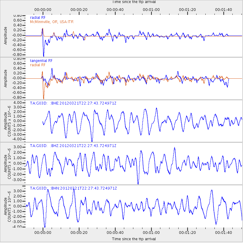
G03D McMinnville, OR, USA - Earthquake Result Viewer
*The percent match for this event was below the threshold and hence no stack was calculated.
| Earthquake location: |
New Guinea, Papua New Guinea |
| Earthquake latitude/longitude: |
-6.2/146.0 |
| Earthquake time(UTC): |
2012/03/21 (081) 22:15:06 GMT |
| Earthquake Depth: |
118 km |
| Earthquake Magnitude: |
6.3 MB, 6.6 MW, 6.6 MW |
| Earthquake Catalog/Contributor: |
WHDF/NEIC |
|
| Network: |
TA USArray Transportable Network (new EarthScope stations) |
| Station: |
G03D McMinnville, OR, USA |
| Lat/Lon: |
45.21 N/123.26 W |
| Elevation: |
222 m |
|
| Distance: |
94.9 deg |
| Az: |
45.189 deg |
| Baz: |
266.158 deg |
| Ray Param: |
$rayparam |
*The percent match for this event was below the threshold and hence was not used in the summary stack. |
|
| Radial Match: |
52.04448 % |
| Radial Bump: |
400 |
| Transverse Match: |
56.98356 % |
| Transverse Bump: |
400 |
| SOD ConfigId: |
440406 |
| Insert Time: |
2012-06-03 02:57:08.967 +0000 |
| GWidth: |
2.5 |
| Max Bumps: |
400 |
| Tol: |
0.001 |
|
Signal To Noise
| Channel | StoN | STA | LTA |
| TA:G03D: :BHZ:20120321T22:27:43.724971Z | 1.1817425 | 1.3554511E-6 | 1.1469936E-6 |
| TA:G03D: :BHN:20120321T22:27:43.724971Z | 2.1123247 | 2.2967763E-6 | 1.0873216E-6 |
| TA:G03D: :BHE:20120321T22:27:43.724971Z | 1.045337 | 1.5714842E-6 | 1.5033279E-6 |
| Arrivals |
| Ps | |
| PpPs | |
| PsPs/PpSs | |


