You are here: Home > Network List > TA - USArray Transportable Network (new EarthScope stations) Stations List
> Station TOLK Tollok Lake Research Station, AK, USA > Earthquake Result Viewer
TOLK Tollok Lake Research Station, AK, USA - Earthquake Result Viewer
| Earthquake location: |
New Guinea, Papua New Guinea |
| Earthquake latitude/longitude: |
-6.2/146.0 |
| Earthquake time(UTC): |
2012/03/21 (081) 22:15:06 GMT |
| Earthquake Depth: |
118 km |
| Earthquake Magnitude: |
6.3 MB, 6.6 MW, 6.6 MW |
| Earthquake Catalog/Contributor: |
WHDF/NEIC |
|
| Network: |
TA USArray Transportable Network (new EarthScope stations) |
| Station: |
TOLK Tollok Lake Research Station, AK, USA |
| Lat/Lon: |
68.64 N/149.57 W |
| Elevation: |
760 m |
|
| Distance: |
86.8 deg |
| Az: |
19.336 deg |
| Baz: |
243.966 deg |
| Ray Param: |
0.043557413 |
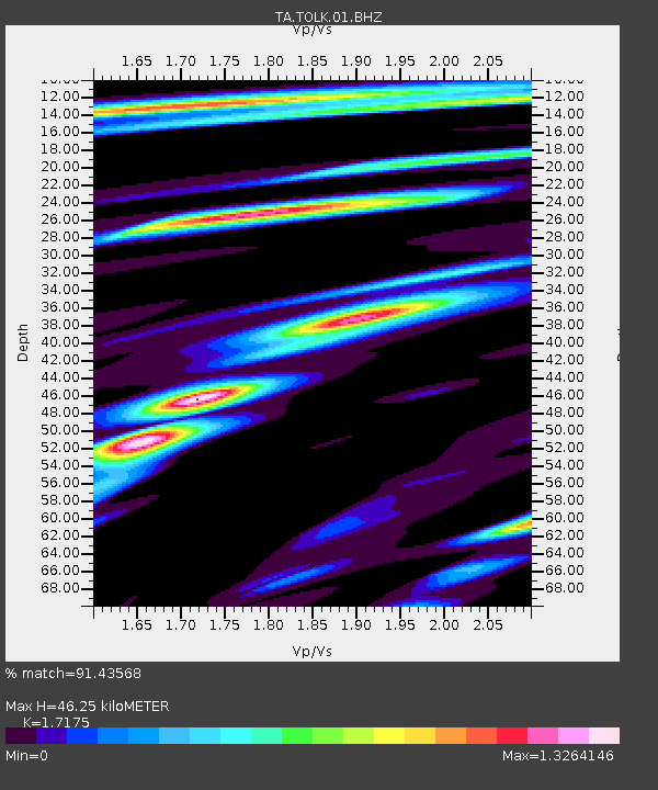
| Estimated Moho Depth: |
46.25 km |
| Estimated Crust Vp/Vs: |
1.72 |
| Assumed Crust Vp: |
6.316 km/s |
| Estimated Crust Vs: |
3.678 km/s |
| Estimated Crust Poisson's Ratio: |
0.24 |
|
| Radial Match: |
91.43568 % |
| Radial Bump: |
400 |
| Transverse Match: |
86.39634 % |
| Transverse Bump: |
400 |
| SOD ConfigId: |
440406 |
| Insert Time: |
2012-06-03 02:57:27.926 +0000 |
| GWidth: |
2.5 |
| Max Bumps: |
400 |
| Tol: |
0.001 |
|

Signal To Noise
| Channel | StoN | STA | LTA |
| TA:TOLK:01:BHZ:20120321T22:27:05.849971Z | 13.30476 | 2.3964624E-6 | 1.8012068E-7 |
| TA:TOLK:01:BHN:20120321T22:27:05.849971Z | 2.8472521 | 4.5291264E-7 | 1.5907008E-7 |
| TA:TOLK:01:BHE:20120321T22:27:05.849971Z | 10.184469 | 7.4449224E-7 | 7.3100736E-8 |
| Arrivals |
| Ps | 5.4 SECOND |
| PpPs | 19 SECOND |
| PsPs/PpSs | 25 SECOND |


