You are here: Home > Network List > UW - Pacific Northwest Regional Seismic Network Stations List
> Station WOLL Wollman Farm, Schrag, WA, USA > Earthquake Result Viewer
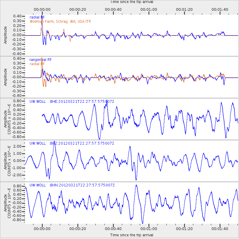
WOLL Wollman Farm, Schrag, WA, USA - Earthquake Result Viewer
*The percent match for this event was below the threshold and hence no stack was calculated.
| Earthquake location: |
New Guinea, Papua New Guinea |
| Earthquake latitude/longitude: |
-6.2/146.0 |
| Earthquake time(UTC): |
2012/03/21 (081) 22:15:06 GMT |
| Earthquake Depth: |
118 km |
| Earthquake Magnitude: |
6.3 MB, 6.6 MW, 6.6 MW |
| Earthquake Catalog/Contributor: |
WHDF/NEIC |
|
| Network: |
UW Pacific Northwest Regional Seismic Network |
| Station: |
WOLL Wollman Farm, Schrag, WA, USA |
| Lat/Lon: |
47.06 N/118.92 W |
| Elevation: |
385 m |
|
| Distance: |
98.0 deg |
| Az: |
43.449 deg |
| Baz: |
269.476 deg |
| Ray Param: |
$rayparam |
*The percent match for this event was below the threshold and hence was not used in the summary stack. |
|
| Radial Match: |
71.18619 % |
| Radial Bump: |
400 |
| Transverse Match: |
50.53372 % |
| Transverse Bump: |
390 |
| SOD ConfigId: |
440406 |
| Insert Time: |
2012-06-03 02:58:25.393 +0000 |
| GWidth: |
2.5 |
| Max Bumps: |
400 |
| Tol: |
0.001 |
|
Signal To Noise
| Channel | StoN | STA | LTA |
| UW:WOLL: :BHZ:20120321T22:27:57.575007Z | 3.3070629 | 1.3796374E-6 | 4.1717905E-7 |
| UW:WOLL: :BHN:20120321T22:27:57.575007Z | 0.674915 | 3.49291E-7 | 5.1753335E-7 |
| UW:WOLL: :BHE:20120321T22:27:57.575007Z | 3.2585974 | 5.531624E-7 | 1.6975476E-7 |
| Arrivals |
| Ps | |
| PpPs | |
| PsPs/PpSs | |


