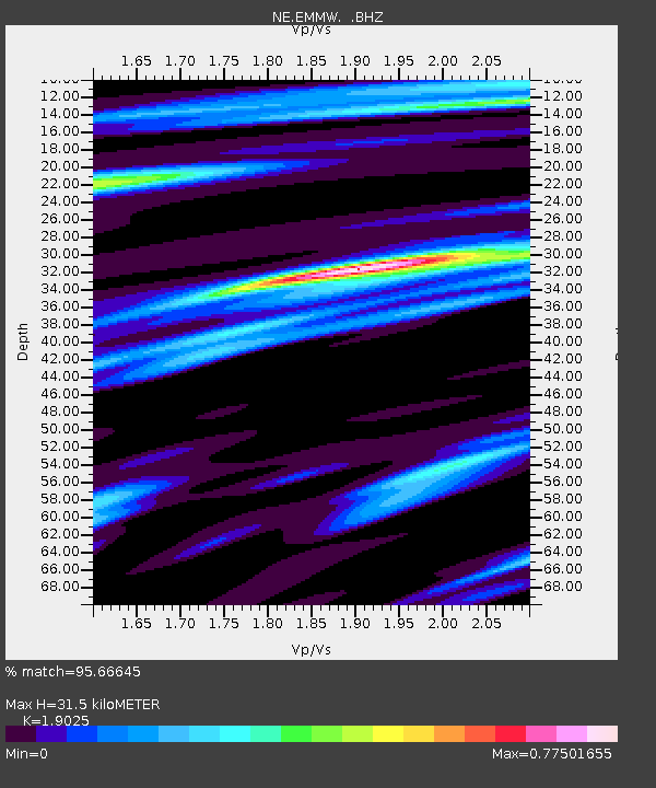
EMMW Machias, ME - Earthquake Result Viewer

Earthquake location: Near Coast Of Central Chile
Earthquake latitude/longitude: -35.2/-72.2
Earthquake time(UTC): 2012/03/25 (085) 22:37:06 GMT
Earthquake Depth: 41 km
Earthquake Magnitude: 6.5 MB, 7.0 MS, 7.1 MW, 7.1 MW
Earthquake Catalog/Contributor: WHDF/NEIC
Network: NE New England Seismic Network
Station: EMMW Machias, ME
Lat/Lon: 44.71 N/67.46 W
Elevation: 34 m
Distance: 79.7 deg
Az: 3.448 deg
Baz: 183.96 deg
Ray Param: 0.04874822
Estimated Moho Depth: 31.5 km
Estimated Crust Vp/Vs: 1.90
Assumed Crust Vp: 6.419 km/s
Estimated Crust Vs: 3.374 km/s
Estimated Crust Poisson's Ratio: 0.31
Radial Match: 95.66645 %
Radial Bump: 323
Transverse Match: 86.291016 %
Transverse Bump: 400
SOD ConfigId: 440406
Insert Time: 2012-06-08 05:34:15.822 +0000
GWidth: 2.5
Max Bumps: 400
Tol: 0.001

Signal To Noise

ChannelStoNSTALTA
NE:EMMW: :BHZ:20120325T22:48:38.184998Z2.765756.1967427E-72.2405291E-7
NE:EMMW: :BHN:20120325T22:48:38.184998Z1.01868522.796684E-72.745386E-7
NE:EMMW: :BHE:20120325T22:48:38.184998Z1.57758273.148477E-71.9957604E-7
Arrivals
Ps4.5 SECOND
PpPs14 SECOND
PsPs/PpSs18 SECOND