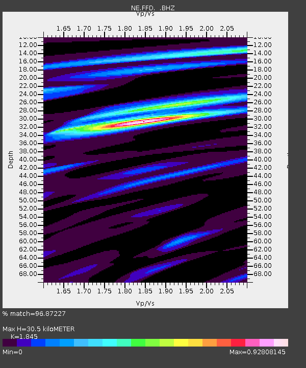
FFD Franklin Falls Dam, NH - Earthquake Result Viewer

Earthquake location: Near Coast Of Central Chile
Earthquake latitude/longitude: -35.2/-72.2
Earthquake time(UTC): 2012/03/25 (085) 22:37:06 GMT
Earthquake Depth: 41 km
Earthquake Magnitude: 6.5 MB, 7.0 MS, 7.1 MW, 7.1 MW
Earthquake Catalog/Contributor: WHDF/NEIC
Network: NE New England Seismic Network
Station: FFD Franklin Falls Dam, NH
Lat/Lon: 43.47 N/71.65 W
Elevation: 131 m
Distance: 78.3 deg
Az: 0.419 deg
Baz: 180.471 deg
Ray Param: 0.04967097
Estimated Moho Depth: 30.5 km
Estimated Crust Vp/Vs: 1.85
Assumed Crust Vp: 6.419 km/s
Estimated Crust Vs: 3.479 km/s
Estimated Crust Poisson's Ratio: 0.29
Radial Match: 96.87227 %
Radial Bump: 272
Transverse Match: 87.57642 %
Transverse Bump: 400
SOD ConfigId: 440406
Insert Time: 2012-06-08 05:34:19.920 +0000
GWidth: 2.5
Max Bumps: 400
Tol: 0.001

Signal To Noise

ChannelStoNSTALTA
NE:FFD: :BHZ:20120325T22:48:30.775024Z3.873369.0553476E-72.3378533E-7
NE:FFD: :BHN:20120325T22:48:30.775024Z2.2797024.366585E-71.9154193E-7
NE:FFD: :BHE:20120325T22:48:30.775024Z0.86979962.2096675E-72.5404327E-7
Arrivals
Ps4.1 SECOND
PpPs13 SECOND
PsPs/PpSs17 SECOND