You are here: Home > Network List > G - GEOSCOPE Stations List
> Station INU Inuyama, Japan > Earthquake Result Viewer
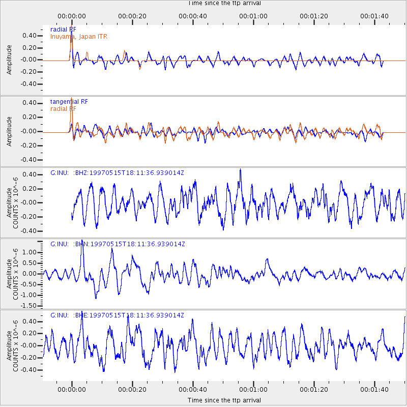
INU Inuyama, Japan - Earthquake Result Viewer
*The percent match for this event was below the threshold and hence no stack was calculated.
| Earthquake location: |
Southeast Of Loyalty Islands |
| Earthquake latitude/longitude: |
-21.6/169.9 |
| Earthquake time(UTC): |
1997/05/15 (135) 18:01:33 GMT |
| Earthquake Depth: |
33 km |
| Earthquake Magnitude: |
5.3 MB, 5.6 MS, 6.0 UNKNOWN, 5.9 MW |
| Earthquake Catalog/Contributor: |
WHDF/NEIC |
|
| Network: |
G GEOSCOPE |
| Station: |
INU Inuyama, Japan |
| Lat/Lon: |
35.35 N/137.03 E |
| Elevation: |
132 m |
|
| Distance: |
64.7 deg |
| Az: |
330.62 deg |
| Baz: |
146.055 deg |
| Ray Param: |
$rayparam |
*The percent match for this event was below the threshold and hence was not used in the summary stack. |
|
| Radial Match: |
70.785065 % |
| Radial Bump: |
400 |
| Transverse Match: |
59.356808 % |
| Transverse Bump: |
400 |
| SOD ConfigId: |
4480 |
| Insert Time: |
2010-02-26 23:23:43.224 +0000 |
| GWidth: |
2.5 |
| Max Bumps: |
400 |
| Tol: |
0.001 |
|
Signal To Noise
| Channel | StoN | STA | LTA |
| G:INU: :BHN:19970515T18:11:36.939014Z | 3.530462 | 5.784024E-7 | 1.6383194E-7 |
| G:INU: :BHE:19970515T18:11:36.939014Z | 1.171838 | 2.1733388E-7 | 1.8546409E-7 |
| G:INU: :BHZ:19970515T18:11:36.939014Z | 1.0805701 | 1.6255197E-7 | 1.5043167E-7 |
| Arrivals |
| Ps | |
| PpPs | |
| PsPs/PpSs | |


