You are here: Home > Network List > TA - USArray Transportable Network (new EarthScope stations) Stations List
> Station R11A Troy Canyon, Currant, NV, USA > Earthquake Result Viewer
R11A Troy Canyon, Currant, NV, USA - Earthquake Result Viewer
| Earthquake location: |
Near Coast Of Central Chile |
| Earthquake latitude/longitude: |
-35.2/-72.2 |
| Earthquake time(UTC): |
2012/03/25 (085) 22:37:06 GMT |
| Earthquake Depth: |
41 km |
| Earthquake Magnitude: |
6.5 MB, 7.0 MS, 7.1 MW, 7.1 MW |
| Earthquake Catalog/Contributor: |
WHDF/NEIC |
|
| Network: |
TA USArray Transportable Network (new EarthScope stations) |
| Station: |
R11A Troy Canyon, Currant, NV, USA |
| Lat/Lon: |
38.35 N/115.59 W |
| Elevation: |
1756 m |
|
| Distance: |
83.5 deg |
| Az: |
327.082 deg |
| Baz: |
145.526 deg |
| Ray Param: |
0.04609461 |
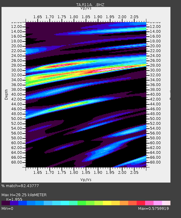
| Estimated Moho Depth: |
29.25 km |
| Estimated Crust Vp/Vs: |
1.96 |
| Assumed Crust Vp: |
6.276 km/s |
| Estimated Crust Vs: |
3.21 km/s |
| Estimated Crust Poisson's Ratio: |
0.32 |
|
| Radial Match: |
92.43777 % |
| Radial Bump: |
364 |
| Transverse Match: |
65.25356 % |
| Transverse Bump: |
400 |
| SOD ConfigId: |
440406 |
| Insert Time: |
2012-06-08 05:38:55.654 +0000 |
| GWidth: |
2.5 |
| Max Bumps: |
400 |
| Tol: |
0.001 |
|

Signal To Noise
| Channel | StoN | STA | LTA |
| TA:R11A: :BHZ:20120325T22:48:58.299988Z | 1.306644 | 6.94163E-7 | 5.3125643E-7 |
| TA:R11A: :BHN:20120325T22:48:58.299988Z | 0.51360816 | 2.3034089E-7 | 4.4847593E-7 |
| TA:R11A: :BHE:20120325T22:48:58.299988Z | 0.7267341 | 1.8156231E-7 | 2.498332E-7 |
| Arrivals |
| Ps | 4.5 SECOND |
| PpPs | 13 SECOND |
| PsPs/PpSs | 18 SECOND |


