You are here: Home > Network List > G - GEOSCOPE Stations List
> Station INU Inuyama, Japan > Earthquake Result Viewer
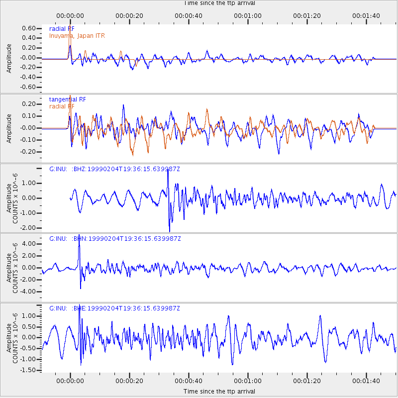
INU Inuyama, Japan - Earthquake Result Viewer
*The percent match for this event was below the threshold and hence no stack was calculated.
| Earthquake location: |
Northern Sumatra, Indonesia |
| Earthquake latitude/longitude: |
4.0/95.3 |
| Earthquake time(UTC): |
1999/02/04 (035) 19:28:00 GMT |
| Earthquake Depth: |
56 km |
| Earthquake Magnitude: |
5.8 MB, 5.4 MS, 5.9 MW, 5.9 MW |
| Earthquake Catalog/Contributor: |
WHDF/NEIC |
|
| Network: |
G GEOSCOPE |
| Station: |
INU Inuyama, Japan |
| Lat/Lon: |
35.35 N/137.03 E |
| Elevation: |
132 m |
|
| Distance: |
49.6 deg |
| Az: |
45.656 deg |
| Baz: |
240.775 deg |
| Ray Param: |
$rayparam |
*The percent match for this event was below the threshold and hence was not used in the summary stack. |
|
| Radial Match: |
56.066677 % |
| Radial Bump: |
400 |
| Transverse Match: |
47.334217 % |
| Transverse Bump: |
400 |
| SOD ConfigId: |
4480 |
| Insert Time: |
2010-02-26 23:23:46.099 +0000 |
| GWidth: |
2.5 |
| Max Bumps: |
400 |
| Tol: |
0.001 |
|
Signal To Noise
| Channel | StoN | STA | LTA |
| G:INU: :BHN:19990204T19:36:15.639987Z | 4.7927265 | 1.5977122E-6 | 3.3336184E-7 |
| G:INU: :BHE:19990204T19:36:15.639987Z | 1.8805205 | 5.7946426E-7 | 3.081404E-7 |
| G:INU: :BHZ:19990204T19:36:15.639987Z | 2.4240582 | 8.832543E-7 | 3.6437012E-7 |
| Arrivals |
| Ps | |
| PpPs | |
| PsPs/PpSs | |


