You are here: Home > Network List > TA - USArray Transportable Network (new EarthScope stations) Stations List
> Station D31A Mcclaflin, Tower City, ND, USA > Earthquake Result Viewer
D31A Mcclaflin, Tower City, ND, USA - Earthquake Result Viewer

| Earthquake location: |
Near Coast Of Central Chile |
| Earthquake latitude/longitude: |
-35.2/-72.2 |
| Earthquake time(UTC): |
2012/03/25 (085) 22:37:06 GMT |
| Earthquake Depth: |
41 km |
| Earthquake Magnitude: |
6.5 MB, 7.0 MS, 7.1 MW, 7.1 MW |
| Earthquake Catalog/Contributor: |
WHDF/NEIC |
|
| Network: |
TA USArray Transportable Network (new EarthScope stations) |
| Station: |
D31A Mcclaflin, Tower City, ND, USA |
| Lat/Lon: |
47.05 N/97.72 W |
| Elevation: |
359 m |
|
| Distance: |
85.0 deg |
| Az: |
342.808 deg |
| Baz: |
159.269 deg |
| Ray Param: |
0.045000482 |
| Estimated Moho Depth: |
35.25 km |
| Estimated Crust Vp/Vs: |
1.76 |
| Assumed Crust Vp: |
6.498 km/s |
| Estimated Crust Vs: |
3.681 km/s |
| Estimated Crust Poisson's Ratio: |
0.26 |
|
| Radial Match: |
96.80346 % |
| Radial Bump: |
400 |
| Transverse Match: |
89.389915 % |
| Transverse Bump: |
400 |
| SOD ConfigId: |
440406 |
| Insert Time: |
2012-06-08 05:41:27.637 +0000 |
| GWidth: |
2.5 |
| Max Bumps: |
400 |
| Tol: |
0.001 |
|
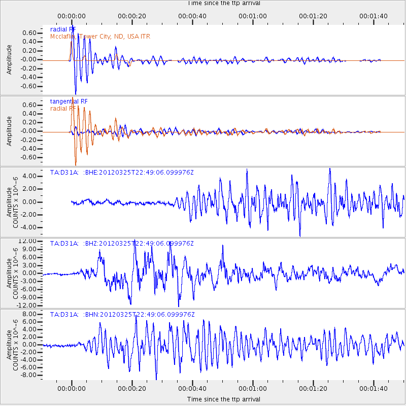
Signal To Noise
| Channel | StoN | STA | LTA |
| TA:D31A: :BHZ:20120325T22:49:06.099976Z | 3.2977319 | 7.0697104E-7 | 2.1438099E-7 |
| TA:D31A: :BHN:20120325T22:49:06.099976Z | 1.9633307 | 4.3752365E-7 | 2.2284766E-7 |
| TA:D31A: :BHE:20120325T22:49:06.099976Z | 1.2628895 | 2.739987E-7 | 2.1696172E-7 |
| Arrivals |
| Ps | 4.3 SECOND |
| PpPs | 15 SECOND |
| PsPs/PpSs | 19 SECOND |


