You are here: Home > Network List > TA - USArray Transportable Network (new EarthScope stations) Stations List
> Station D33A AnnSam, Waubun, MN, USA > Earthquake Result Viewer
D33A AnnSam, Waubun, MN, USA - Earthquake Result Viewer

| Earthquake location: |
Near Coast Of Central Chile |
| Earthquake latitude/longitude: |
-35.2/-72.2 |
| Earthquake time(UTC): |
2012/03/25 (085) 22:37:06 GMT |
| Earthquake Depth: |
41 km |
| Earthquake Magnitude: |
6.5 MB, 7.0 MS, 7.1 MW, 7.1 MW |
| Earthquake Catalog/Contributor: |
WHDF/NEIC |
|
| Network: |
TA USArray Transportable Network (new EarthScope stations) |
| Station: |
D33A AnnSam, Waubun, MN, USA |
| Lat/Lon: |
47.14 N/95.84 W |
| Elevation: |
466 m |
|
| Distance: |
84.7 deg |
| Az: |
344.05 deg |
| Baz: |
160.752 deg |
| Ray Param: |
0.04525305 |
| Estimated Moho Depth: |
28.75 km |
| Estimated Crust Vp/Vs: |
1.88 |
| Assumed Crust Vp: |
6.419 km/s |
| Estimated Crust Vs: |
3.419 km/s |
| Estimated Crust Poisson's Ratio: |
0.30 |
|
| Radial Match: |
85.287674 % |
| Radial Bump: |
400 |
| Transverse Match: |
63.289944 % |
| Transverse Bump: |
400 |
| SOD ConfigId: |
440406 |
| Insert Time: |
2012-06-08 05:42:57.031 +0000 |
| GWidth: |
2.5 |
| Max Bumps: |
400 |
| Tol: |
0.001 |
|
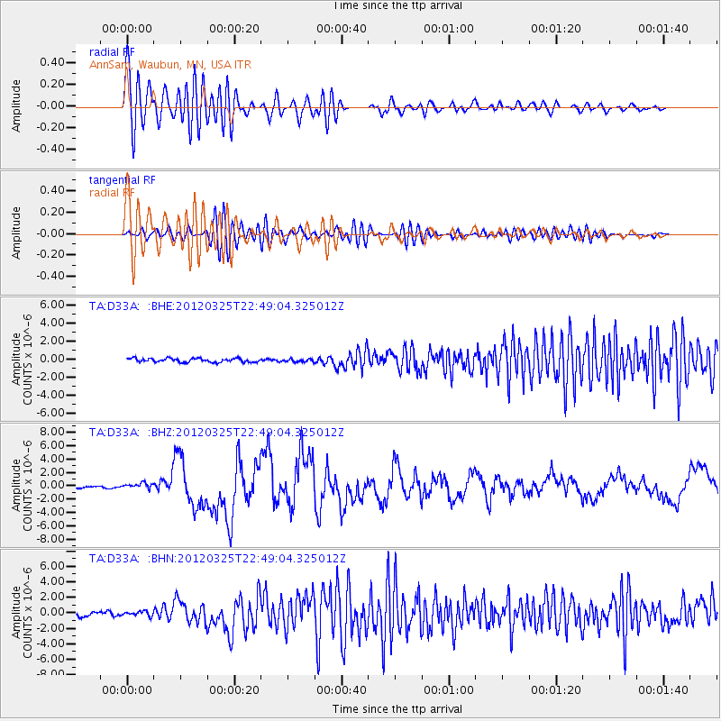
Signal To Noise
| Channel | StoN | STA | LTA |
| TA:D33A: :BHZ:20120325T22:49:04.325012Z | 1.947745 | 4.3979784E-7 | 2.2579847E-7 |
| TA:D33A: :BHN:20120325T22:49:04.325012Z | 1.173022 | 2.9985816E-7 | 2.5562875E-7 |
| TA:D33A: :BHE:20120325T22:49:04.325012Z | 0.77561533 | 1.6063136E-7 | 2.0710183E-7 |
| Arrivals |
| Ps | 4.0 SECOND |
| PpPs | 13 SECOND |
| PsPs/PpSs | 17 SECOND |


