You are here: Home > Network List > TA - USArray Transportable Network (new EarthScope stations) Stations List
> Station D37A Cotton, MN, USA > Earthquake Result Viewer
D37A Cotton, MN, USA - Earthquake Result Viewer
| Earthquake location: |
Near Coast Of Central Chile |
| Earthquake latitude/longitude: |
-35.2/-72.2 |
| Earthquake time(UTC): |
2012/03/25 (085) 22:37:06 GMT |
| Earthquake Depth: |
41 km |
| Earthquake Magnitude: |
6.5 MB, 7.0 MS, 7.1 MW, 7.1 MW |
| Earthquake Catalog/Contributor: |
WHDF/NEIC |
|
| Network: |
TA USArray Transportable Network (new EarthScope stations) |
| Station: |
D37A Cotton, MN, USA |
| Lat/Lon: |
47.16 N/92.43 W |
| Elevation: |
413 m |
|
| Distance: |
84.0 deg |
| Az: |
346.287 deg |
| Baz: |
163.472 deg |
| Ray Param: |
0.045747165 |
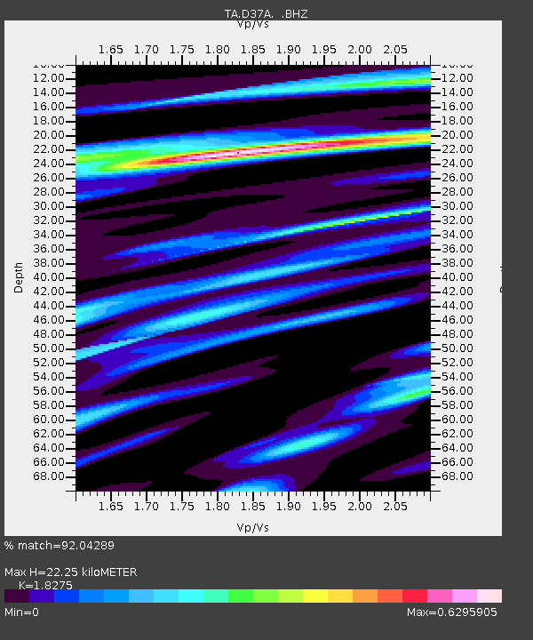
| Estimated Moho Depth: |
22.25 km |
| Estimated Crust Vp/Vs: |
1.83 |
| Assumed Crust Vp: |
6.571 km/s |
| Estimated Crust Vs: |
3.595 km/s |
| Estimated Crust Poisson's Ratio: |
0.29 |
|
| Radial Match: |
92.04289 % |
| Radial Bump: |
400 |
| Transverse Match: |
79.311 % |
| Transverse Bump: |
400 |
| SOD ConfigId: |
440406 |
| Insert Time: |
2012-06-08 05:43:09.939 +0000 |
| GWidth: |
2.5 |
| Max Bumps: |
400 |
| Tol: |
0.001 |
|
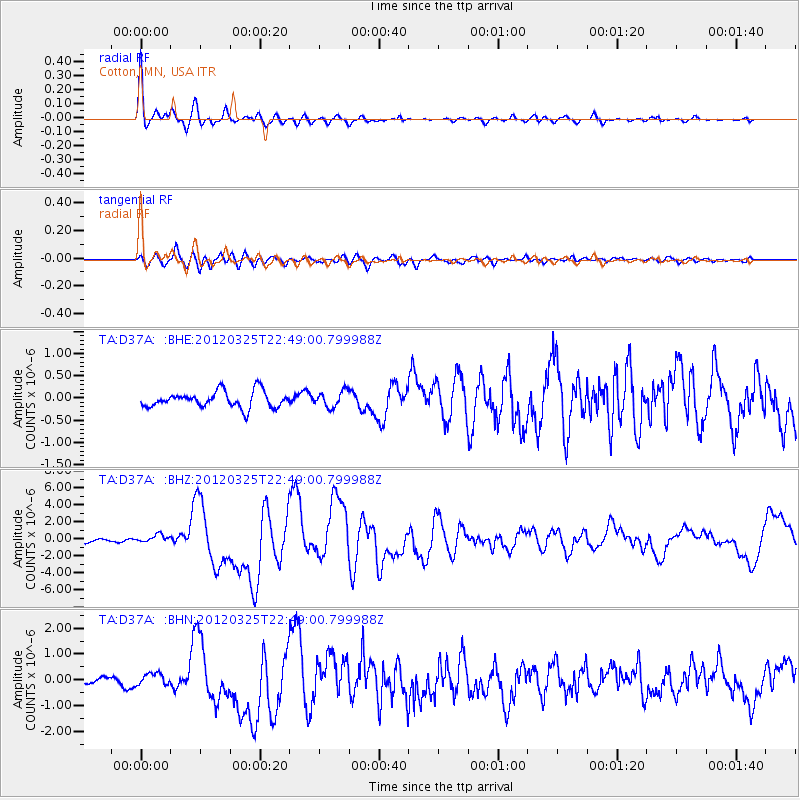
Signal To Noise
| Channel | StoN | STA | LTA |
| TA:D37A: :BHZ:20120325T22:49:00.799988Z | 2.495359 | 4.754408E-7 | 1.9053002E-7 |
| TA:D37A: :BHN:20120325T22:49:00.799988Z | 1.4330381 | 2.4128227E-7 | 1.6837114E-7 |
| TA:D37A: :BHE:20120325T22:49:00.799988Z | 0.99047315 | 1.7971146E-7 | 1.8144002E-7 |
| Arrivals |
| Ps | 2.9 SECOND |
| PpPs | 9.3 SECOND |
| PsPs/PpSs | 12 SECOND |


