You are here: Home > Network List > TA - USArray Transportable Network (new EarthScope stations) Stations List
> Station N38A Joe's South Fork Station, Corydon, IA, USA > Earthquake Result Viewer
N38A Joe's South Fork Station, Corydon, IA, USA - Earthquake Result Viewer

| Earthquake location: |
Near Coast Of Central Chile |
| Earthquake latitude/longitude: |
-35.2/-72.2 |
| Earthquake time(UTC): |
2012/03/25 (085) 22:37:06 GMT |
| Earthquake Depth: |
41 km |
| Earthquake Magnitude: |
6.5 MB, 7.0 MS, 7.1 MW, 7.1 MW |
| Earthquake Catalog/Contributor: |
WHDF/NEIC |
|
| Network: |
TA USArray Transportable Network (new EarthScope stations) |
| Station: |
N38A Joe's South Fork Station, Corydon, IA, USA |
| Lat/Lon: |
40.79 N/93.24 W |
| Elevation: |
317 m |
|
| Distance: |
78.1 deg |
| Az: |
343.839 deg |
| Baz: |
162.529 deg |
| Ray Param: |
0.049835797 |
| Estimated Moho Depth: |
36.5 km |
| Estimated Crust Vp/Vs: |
2.03 |
| Assumed Crust Vp: |
6.498 km/s |
| Estimated Crust Vs: |
3.209 km/s |
| Estimated Crust Poisson's Ratio: |
0.34 |
|
| Radial Match: |
94.02187 % |
| Radial Bump: |
400 |
| Transverse Match: |
81.00189 % |
| Transverse Bump: |
400 |
| SOD ConfigId: |
440406 |
| Insert Time: |
2012-06-08 05:45:35.845 +0000 |
| GWidth: |
2.5 |
| Max Bumps: |
400 |
| Tol: |
0.001 |
|
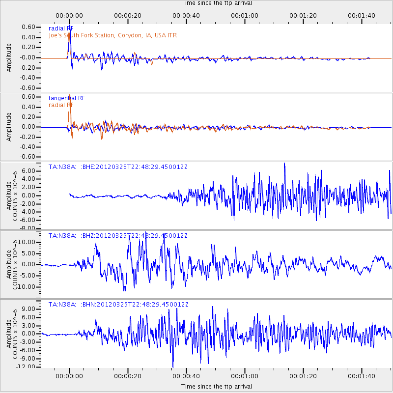
Signal To Noise
| Channel | StoN | STA | LTA |
| TA:N38A: :BHZ:20120325T22:48:29.450012Z | 4.4396195 | 8.7980555E-7 | 1.9817138E-7 |
| TA:N38A: :BHN:20120325T22:48:29.450012Z | 1.5379732 | 3.4208608E-7 | 2.2242656E-7 |
| TA:N38A: :BHE:20120325T22:48:29.450012Z | 1.3483909 | 2.6912116E-7 | 1.9958688E-7 |
| Arrivals |
| Ps | 5.9 SECOND |
| PpPs | 17 SECOND |
| PsPs/PpSs | 22 SECOND |


