You are here: Home > Network List > TA - USArray Transportable Network (new EarthScope stations) Stations List
> Station O37A Wolven Farm, McFall, MO, USA > Earthquake Result Viewer
O37A Wolven Farm, McFall, MO, USA - Earthquake Result Viewer
| Earthquake location: |
Near Coast Of Central Chile |
| Earthquake latitude/longitude: |
-35.2/-72.2 |
| Earthquake time(UTC): |
2012/03/25 (085) 22:37:06 GMT |
| Earthquake Depth: |
41 km |
| Earthquake Magnitude: |
6.5 MB, 7.0 MS, 7.1 MW, 7.1 MW |
| Earthquake Catalog/Contributor: |
WHDF/NEIC |
|
| Network: |
TA USArray Transportable Network (new EarthScope stations) |
| Station: |
O37A Wolven Farm, McFall, MO, USA |
| Lat/Lon: |
40.17 N/94.15 W |
| Elevation: |
284 m |
|
| Distance: |
77.7 deg |
| Az: |
342.966 deg |
| Baz: |
161.756 deg |
| Ray Param: |
0.050096113 |
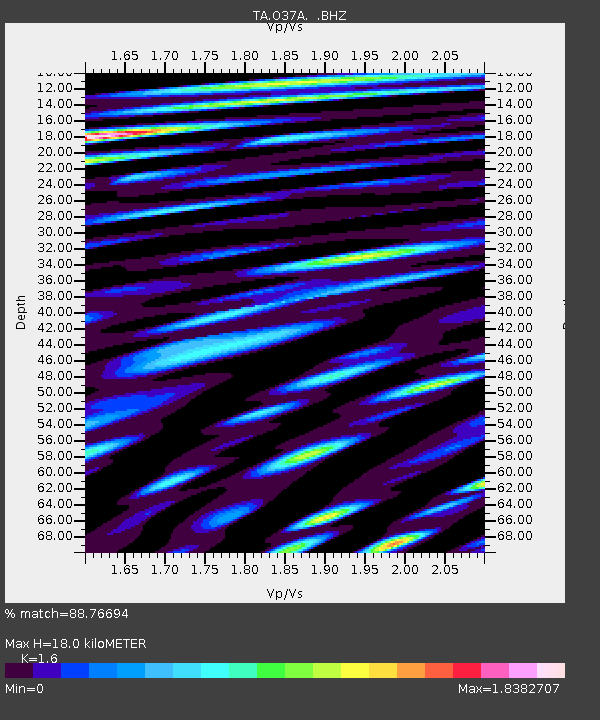
| Estimated Moho Depth: |
18.0 km |
| Estimated Crust Vp/Vs: |
1.60 |
| Assumed Crust Vp: |
6.498 km/s |
| Estimated Crust Vs: |
4.061 km/s |
| Estimated Crust Poisson's Ratio: |
0.18 |
|
| Radial Match: |
88.76694 % |
| Radial Bump: |
400 |
| Transverse Match: |
78.76303 % |
| Transverse Bump: |
400 |
| SOD ConfigId: |
440406 |
| Insert Time: |
2012-06-08 05:45:45.732 +0000 |
| GWidth: |
2.5 |
| Max Bumps: |
400 |
| Tol: |
0.001 |
|
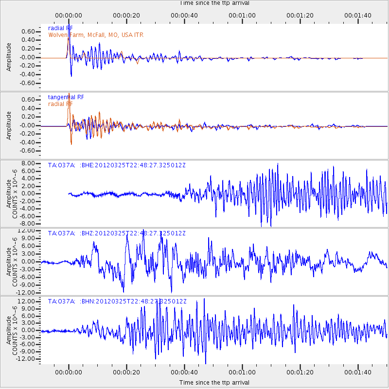
Signal To Noise
| Channel | StoN | STA | LTA |
| TA:O37A: :BHZ:20120325T22:48:27.325012Z | 3.5964963 | 8.3323494E-7 | 2.3167962E-7 |
| TA:O37A: :BHN:20120325T22:48:27.325012Z | 2.4472437 | 6.0915823E-7 | 2.4891605E-7 |
| TA:O37A: :BHE:20120325T22:48:27.325012Z | 1.026034 | 3.0791097E-7 | 3.0009824E-7 |
| Arrivals |
| Ps | 1.7 SECOND |
| PpPs | 7.0 SECOND |
| PsPs/PpSs | 8.7 SECOND |


