You are here: Home > Network List > TA - USArray Transportable Network (new EarthScope stations) Stations List
> Station U39A Green Forest, AR, USA > Earthquake Result Viewer
U39A Green Forest, AR, USA - Earthquake Result Viewer
| Earthquake location: |
Near Coast Of Central Chile |
| Earthquake latitude/longitude: |
-35.2/-72.2 |
| Earthquake time(UTC): |
2012/03/25 (085) 22:37:06 GMT |
| Earthquake Depth: |
41 km |
| Earthquake Magnitude: |
6.5 MB, 7.0 MS, 7.1 MW, 7.1 MW |
| Earthquake Catalog/Contributor: |
WHDF/NEIC |
|
| Network: |
TA USArray Transportable Network (new EarthScope stations) |
| Station: |
U39A Green Forest, AR, USA |
| Lat/Lon: |
36.38 N/93.48 W |
| Elevation: |
433 m |
|
| Distance: |
73.9 deg |
| Az: |
342.268 deg |
| Baz: |
161.995 deg |
| Ray Param: |
0.05261283 |
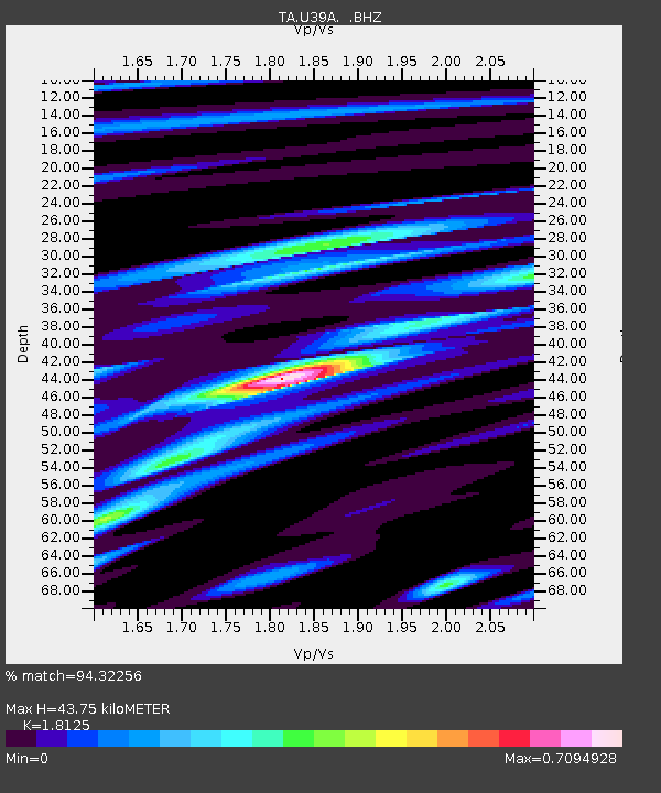
| Estimated Moho Depth: |
43.75 km |
| Estimated Crust Vp/Vs: |
1.81 |
| Assumed Crust Vp: |
6.53 km/s |
| Estimated Crust Vs: |
3.603 km/s |
| Estimated Crust Poisson's Ratio: |
0.28 |
|
| Radial Match: |
94.32256 % |
| Radial Bump: |
397 |
| Transverse Match: |
64.99645 % |
| Transverse Bump: |
400 |
| SOD ConfigId: |
440406 |
| Insert Time: |
2012-06-08 05:47:17.998 +0000 |
| GWidth: |
2.5 |
| Max Bumps: |
400 |
| Tol: |
0.001 |
|

Signal To Noise
| Channel | StoN | STA | LTA |
| TA:U39A: :BHZ:20120325T22:48:05.950012Z | 3.4843607 | 1.0900097E-6 | 3.1282917E-7 |
| TA:U39A: :BHN:20120325T22:48:05.950012Z | 2.4852142 | 3.2154642E-7 | 1.2938378E-7 |
| TA:U39A: :BHE:20120325T22:48:05.950012Z | 1.75521 | 4.4318435E-7 | 2.5249648E-7 |
| Arrivals |
| Ps | 5.6 SECOND |
| PpPs | 18 SECOND |
| PsPs/PpSs | 24 SECOND |


