You are here: Home > Network List > TA - USArray Transportable Network (new EarthScope stations) Stations List
> Station Y47A UCPARC, Winfield, AL, USA > Earthquake Result Viewer
Y47A UCPARC, Winfield, AL, USA - Earthquake Result Viewer
| Earthquake location: |
Near Coast Of Central Chile |
| Earthquake latitude/longitude: |
-35.2/-72.2 |
| Earthquake time(UTC): |
2012/03/25 (085) 22:37:06 GMT |
| Earthquake Depth: |
41 km |
| Earthquake Magnitude: |
6.5 MB, 7.0 MS, 7.1 MW, 7.1 MW |
| Earthquake Catalog/Contributor: |
WHDF/NEIC |
|
| Network: |
TA USArray Transportable Network (new EarthScope stations) |
| Station: |
Y47A UCPARC, Winfield, AL, USA |
| Lat/Lon: |
33.90 N/87.85 W |
| Elevation: |
160 m |
|
| Distance: |
70.3 deg |
| Az: |
346.227 deg |
| Baz: |
166.442 deg |
| Ray Param: |
0.055012994 |
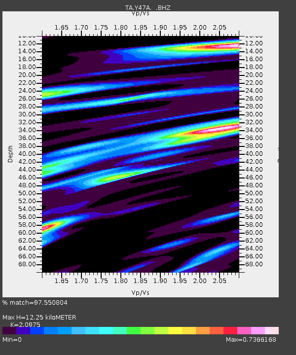
| Estimated Moho Depth: |
12.25 km |
| Estimated Crust Vp/Vs: |
2.10 |
| Assumed Crust Vp: |
6.565 km/s |
| Estimated Crust Vs: |
3.13 km/s |
| Estimated Crust Poisson's Ratio: |
0.35 |
|
| Radial Match: |
97.550804 % |
| Radial Bump: |
298 |
| Transverse Match: |
94.02987 % |
| Transverse Bump: |
400 |
| SOD ConfigId: |
440406 |
| Insert Time: |
2012-06-08 05:51:21.137 +0000 |
| GWidth: |
2.5 |
| Max Bumps: |
400 |
| Tol: |
0.001 |
|
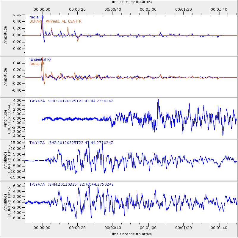
Signal To Noise
| Channel | StoN | STA | LTA |
| TA:Y47A: :BHZ:20120325T22:47:44.275024Z | 4.516752 | 8.2192315E-7 | 1.8197218E-7 |
| TA:Y47A: :BHN:20120325T22:47:44.275024Z | 1.8220265 | 3.8707768E-7 | 2.1244348E-7 |
| TA:Y47A: :BHE:20120325T22:47:44.275024Z | 1.1789938 | 2.121697E-7 | 1.7995828E-7 |
| Arrivals |
| Ps | 2.1 SECOND |
| PpPs | 5.6 SECOND |
| PsPs/PpSs | 7.7 SECOND |


