You are here: Home > Network List > TA - USArray Transportable Network (new EarthScope stations) Stations List
> Station P39B Salisbury, MO, USA > Earthquake Result Viewer
P39B Salisbury, MO, USA - Earthquake Result Viewer

| Earthquake location: |
Near Coast Of Central Chile |
| Earthquake latitude/longitude: |
-35.2/-72.2 |
| Earthquake time(UTC): |
2012/03/25 (085) 22:37:06 GMT |
| Earthquake Depth: |
41 km |
| Earthquake Magnitude: |
6.5 MB, 7.0 MS, 7.1 MW, 7.1 MW |
| Earthquake Catalog/Contributor: |
WHDF/NEIC |
|
| Network: |
TA USArray Transportable Network (new EarthScope stations) |
| Station: |
P39B Salisbury, MO, USA |
| Lat/Lon: |
39.49 N/92.75 W |
| Elevation: |
226 m |
|
| Distance: |
76.7 deg |
| Az: |
343.802 deg |
| Baz: |
162.829 deg |
| Ray Param: |
0.050750963 |
| Estimated Moho Depth: |
43.75 km |
| Estimated Crust Vp/Vs: |
1.77 |
| Assumed Crust Vp: |
6.498 km/s |
| Estimated Crust Vs: |
3.676 km/s |
| Estimated Crust Poisson's Ratio: |
0.26 |
|
| Radial Match: |
95.72964 % |
| Radial Bump: |
369 |
| Transverse Match: |
65.98089 % |
| Transverse Bump: |
400 |
| SOD ConfigId: |
440406 |
| Insert Time: |
2012-06-08 05:52:22.921 +0000 |
| GWidth: |
2.5 |
| Max Bumps: |
400 |
| Tol: |
0.001 |
|
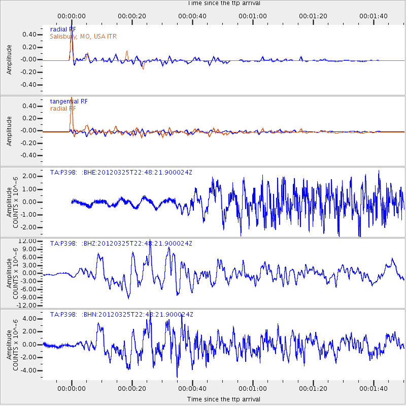
Signal To Noise
| Channel | StoN | STA | LTA |
| TA:P39B: :BHZ:20120325T22:48:21.900024Z | 5.2147765 | 1.1747376E-6 | 2.2527094E-7 |
| TA:P39B: :BHN:20120325T22:48:21.900024Z | 1.4540397 | 3.192753E-7 | 2.1957813E-7 |
| TA:P39B: :BHE:20120325T22:48:21.900024Z | 0.9039747 | 1.8941506E-7 | 2.095358E-7 |
| Arrivals |
| Ps | 5.3 SECOND |
| PpPs | 18 SECOND |
| PsPs/PpSs | 23 SECOND |


