You are here: Home > Network List > TA - USArray Transportable Network (new EarthScope stations) Stations List
> Station X45A UM Field Station, Abbeville, MS, USA > Earthquake Result Viewer
X45A UM Field Station, Abbeville, MS, USA - Earthquake Result Viewer
| Earthquake location: |
Near Coast Of Central Chile |
| Earthquake latitude/longitude: |
-35.2/-72.2 |
| Earthquake time(UTC): |
2012/03/25 (085) 22:37:06 GMT |
| Earthquake Depth: |
41 km |
| Earthquake Magnitude: |
6.5 MB, 7.0 MS, 7.1 MW, 7.1 MW |
| Earthquake Catalog/Contributor: |
WHDF/NEIC |
|
| Network: |
TA USArray Transportable Network (new EarthScope stations) |
| Station: |
X45A UM Field Station, Abbeville, MS, USA |
| Lat/Lon: |
34.42 N/89.39 W |
| Elevation: |
142 m |
|
| Distance: |
71.1 deg |
| Az: |
345.047 deg |
| Baz: |
165.189 deg |
| Ray Param: |
0.05447577 |
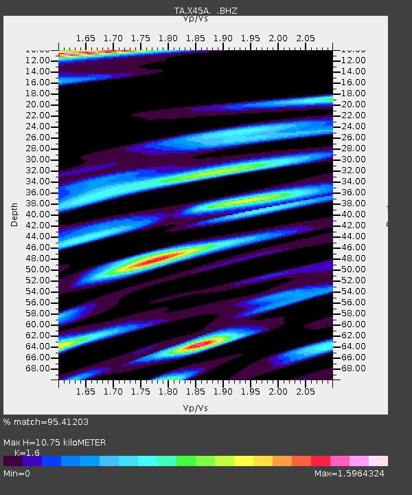
| Estimated Moho Depth: |
10.75 km |
| Estimated Crust Vp/Vs: |
1.60 |
| Assumed Crust Vp: |
6.38 km/s |
| Estimated Crust Vs: |
3.988 km/s |
| Estimated Crust Poisson's Ratio: |
0.18 |
|
| Radial Match: |
95.41203 % |
| Radial Bump: |
346 |
| Transverse Match: |
86.61411 % |
| Transverse Bump: |
400 |
| SOD ConfigId: |
440406 |
| Insert Time: |
2012-06-08 05:52:53.085 +0000 |
| GWidth: |
2.5 |
| Max Bumps: |
400 |
| Tol: |
0.001 |
|
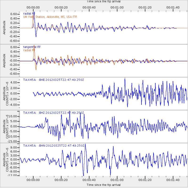
Signal To Noise
| Channel | StoN | STA | LTA |
| TA:X45A: :BHZ:20120325T22:47:49.250Z | 3.9031324 | 9.1891377E-7 | 2.3542981E-7 |
| TA:X45A: :BHN:20120325T22:47:49.250Z | 0.7017652 | 5.5409333E-7 | 7.8957083E-7 |
| TA:X45A: :BHE:20120325T22:47:49.250Z | 0.91736853 | 3.3417004E-7 | 3.642702E-7 |
| Arrivals |
| Ps | 1.1 SECOND |
| PpPs | 4.2 SECOND |
| PsPs/PpSs | 5.3 SECOND |


