You are here: Home > Network List > YT07 - POLENET Stations List
> Station DNTW DNTW > Earthquake Result Viewer
DNTW DNTW - Earthquake Result Viewer
| Earthquake location: |
South Of Fiji Islands |
| Earthquake latitude/longitude: |
-24.6/179.1 |
| Earthquake time(UTC): |
2014/05/04 (124) 09:15:53 GMT |
| Earthquake Depth: |
528 km |
| Earthquake Magnitude: |
6.6 MWP, 6.8 MI |
| Earthquake Catalog/Contributor: |
NEIC PDE/NEIC COMCAT |
|
| Network: |
YT POLENET |
| Station: |
DNTW DNTW |
| Lat/Lon: |
76.45 S/107.78 W |
| Elevation: |
1031 m |
|
| Distance: |
62.3 deg |
| Az: |
165.233 deg |
| Baz: |
280.33 deg |
| Ray Param: |
0.058361117 |
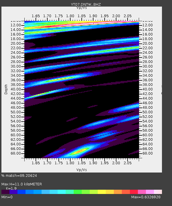
| Estimated Moho Depth: |
11.0 km |
| Estimated Crust Vp/Vs: |
1.90 |
| Assumed Crust Vp: |
5.951 km/s |
| Estimated Crust Vs: |
3.132 km/s |
| Estimated Crust Poisson's Ratio: |
0.31 |
|
| Radial Match: |
89.20624 % |
| Radial Bump: |
286 |
| Transverse Match: |
83.69141 % |
| Transverse Bump: |
400 |
| SOD ConfigId: |
3390531 |
| Insert Time: |
2019-04-11 16:57:55.537 +0000 |
| GWidth: |
2.5 |
| Max Bumps: |
400 |
| Tol: |
0.001 |
|

Signal To Noise
| Channel | StoN | STA | LTA |
| YT:DNTW: :BHZ:20140504T09:24:51.699028Z | 10.289522 | 2.2618865E-6 | 2.1982423E-7 |
| YT:DNTW: :BHN:20140504T09:24:51.699028Z | 6.053709 | 8.7534676E-7 | 1.4459677E-7 |
| YT:DNTW: :BHE:20140504T09:24:51.699028Z | 3.335517 | 1.058018E-6 | 3.171976E-7 |
| Arrivals |
| Ps | 1.7 SECOND |
| PpPs | 5.2 SECOND |
| PsPs/PpSs | 6.9 SECOND |


