You are here: Home > Network List > TA - USArray Transportable Network (new EarthScope stations) Stations List
> Station J40A Soldiers Grove, WI, USA > Earthquake Result Viewer
J40A Soldiers Grove, WI, USA - Earthquake Result Viewer
| Earthquake location: |
Near Coast Of Central Chile |
| Earthquake latitude/longitude: |
-35.2/-72.2 |
| Earthquake time(UTC): |
2012/03/25 (085) 22:37:06 GMT |
| Earthquake Depth: |
41 km |
| Earthquake Magnitude: |
6.5 MB, 7.0 MS, 7.1 MW, 7.1 MW |
| Earthquake Catalog/Contributor: |
WHDF/NEIC |
|
| Network: |
TA USArray Transportable Network (new EarthScope stations) |
| Station: |
J40A Soldiers Grove, WI, USA |
| Lat/Lon: |
43.40 N/90.74 W |
| Elevation: |
353 m |
|
| Distance: |
80.0 deg |
| Az: |
346.401 deg |
| Baz: |
164.682 deg |
| Ray Param: |
0.04849285 |
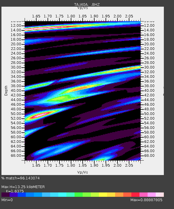
| Estimated Moho Depth: |
13.25 km |
| Estimated Crust Vp/Vs: |
1.64 |
| Assumed Crust Vp: |
6.53 km/s |
| Estimated Crust Vs: |
3.988 km/s |
| Estimated Crust Poisson's Ratio: |
0.20 |
|
| Radial Match: |
96.143074 % |
| Radial Bump: |
400 |
| Transverse Match: |
76.97083 % |
| Transverse Bump: |
400 |
| SOD ConfigId: |
440406 |
| Insert Time: |
2012-06-08 05:54:10.366 +0000 |
| GWidth: |
2.5 |
| Max Bumps: |
400 |
| Tol: |
0.001 |
|
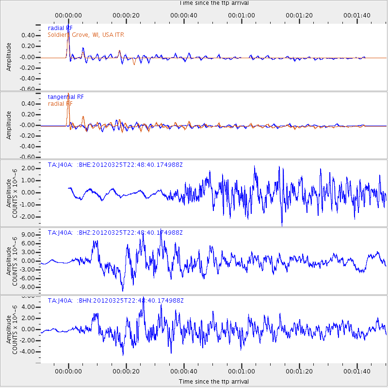
Signal To Noise
| Channel | StoN | STA | LTA |
| TA:J40A: :BHZ:20120325T22:48:40.174988Z | 1.770214 | 6.581421E-7 | 3.7178674E-7 |
| TA:J40A: :BHN:20120325T22:48:40.174988Z | 1.45992 | 3.1636966E-7 | 2.1670343E-7 |
| TA:J40A: :BHE:20120325T22:48:40.174988Z | 0.79795104 | 2.0256144E-7 | 2.5385197E-7 |
| Arrivals |
| Ps | 1.3 SECOND |
| PpPs | 5.2 SECOND |
| PsPs/PpSs | 6.5 SECOND |


