You are here: Home > Network List > TA - USArray Transportable Network (new EarthScope stations) Stations List
> Station M42A Sheffield, IL, USA > Earthquake Result Viewer
M42A Sheffield, IL, USA - Earthquake Result Viewer
| Earthquake location: |
Near Coast Of Central Chile |
| Earthquake latitude/longitude: |
-35.2/-72.2 |
| Earthquake time(UTC): |
2012/03/25 (085) 22:37:06 GMT |
| Earthquake Depth: |
41 km |
| Earthquake Magnitude: |
6.5 MB, 7.0 MS, 7.1 MW, 7.1 MW |
| Earthquake Catalog/Contributor: |
WHDF/NEIC |
|
| Network: |
TA USArray Transportable Network (new EarthScope stations) |
| Station: |
M42A Sheffield, IL, USA |
| Lat/Lon: |
41.45 N/89.76 W |
| Elevation: |
212 m |
|
| Distance: |
78.0 deg |
| Az: |
346.606 deg |
| Baz: |
165.382 deg |
| Ray Param: |
0.049897727 |
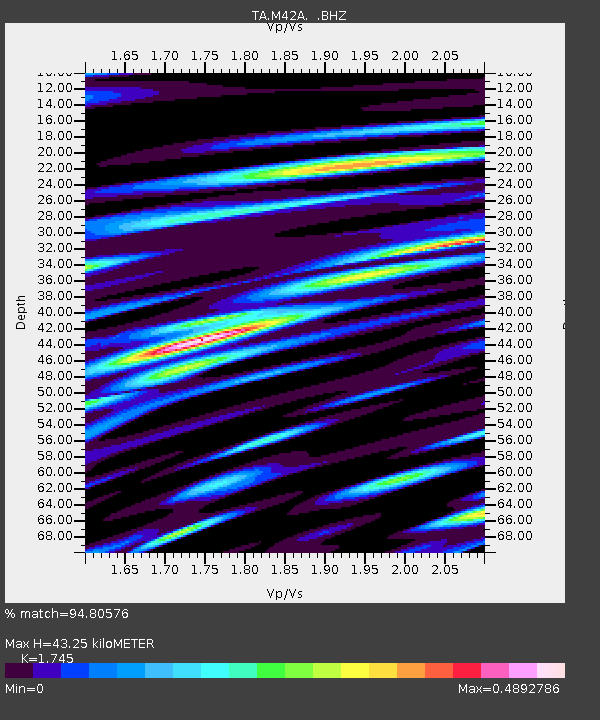
| Estimated Moho Depth: |
43.25 km |
| Estimated Crust Vp/Vs: |
1.75 |
| Assumed Crust Vp: |
6.498 km/s |
| Estimated Crust Vs: |
3.724 km/s |
| Estimated Crust Poisson's Ratio: |
0.26 |
|
| Radial Match: |
94.80576 % |
| Radial Bump: |
400 |
| Transverse Match: |
76.11614 % |
| Transverse Bump: |
400 |
| SOD ConfigId: |
440406 |
| Insert Time: |
2012-06-08 05:55:04.966 +0000 |
| GWidth: |
2.5 |
| Max Bumps: |
400 |
| Tol: |
0.001 |
|

Signal To Noise
| Channel | StoN | STA | LTA |
| TA:M42A: :BHZ:20120325T22:48:28.950012Z | 3.8816764 | 8.466478E-7 | 2.1811395E-7 |
| TA:M42A: :BHN:20120325T22:48:28.950012Z | 1.498473 | 3.9363073E-7 | 2.6268788E-7 |
| TA:M42A: :BHE:20120325T22:48:28.950012Z | 2.0007699 | 4.553047E-7 | 2.2756475E-7 |
| Arrivals |
| Ps | 5.1 SECOND |
| PpPs | 18 SECOND |
| PsPs/PpSs | 23 SECOND |


