You are here: Home > Network List > TA - USArray Transportable Network (new EarthScope stations) Stations List
> Station V43A Jonesboro, AR, USA > Earthquake Result Viewer
V43A Jonesboro, AR, USA - Earthquake Result Viewer
| Earthquake location: |
Near Coast Of Central Chile |
| Earthquake latitude/longitude: |
-35.2/-72.2 |
| Earthquake time(UTC): |
2012/03/25 (085) 22:37:06 GMT |
| Earthquake Depth: |
41 km |
| Earthquake Magnitude: |
6.5 MB, 7.0 MS, 7.1 MW, 7.1 MW |
| Earthquake Catalog/Contributor: |
WHDF/NEIC |
|
| Network: |
TA USArray Transportable Network (new EarthScope stations) |
| Station: |
V43A Jonesboro, AR, USA |
| Lat/Lon: |
35.79 N/90.54 W |
| Elevation: |
74 m |
|
| Distance: |
72.7 deg |
| Az: |
344.465 deg |
| Baz: |
164.349 deg |
| Ray Param: |
0.05344506 |
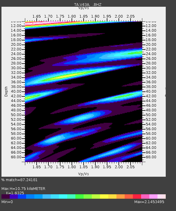
| Estimated Moho Depth: |
10.75 km |
| Estimated Crust Vp/Vs: |
1.63 |
| Assumed Crust Vp: |
6.273 km/s |
| Estimated Crust Vs: |
3.843 km/s |
| Estimated Crust Poisson's Ratio: |
0.20 |
|
| Radial Match: |
87.24181 % |
| Radial Bump: |
400 |
| Transverse Match: |
83.125 % |
| Transverse Bump: |
400 |
| SOD ConfigId: |
440406 |
| Insert Time: |
2012-06-08 05:55:12.214 +0000 |
| GWidth: |
2.5 |
| Max Bumps: |
400 |
| Tol: |
0.001 |
|
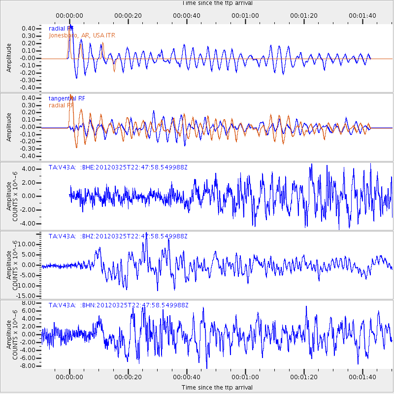
Signal To Noise
| Channel | StoN | STA | LTA |
| TA:V43A: :BHZ:20120325T22:47:58.549988Z | 1.8689907 | 8.253824E-7 | 4.4161933E-7 |
| TA:V43A: :BHN:20120325T22:47:58.549988Z | 0.79502726 | 9.300305E-7 | 1.1698096E-6 |
| TA:V43A: :BHE:20120325T22:47:58.549988Z | 1.0020452 | 6.9175786E-7 | 6.90346E-7 |
| Arrivals |
| Ps | 1.1 SECOND |
| PpPs | 4.4 SECOND |
| PsPs/PpSs | 5.5 SECOND |


