You are here: Home > Network List > TA - USArray Transportable Network (new EarthScope stations) Stations List
> Station U44B Burton Farm, Hornbeak, TN, USA > Earthquake Result Viewer
U44B Burton Farm, Hornbeak, TN, USA - Earthquake Result Viewer
| Earthquake location: |
Near Coast Of Central Chile |
| Earthquake latitude/longitude: |
-35.2/-72.2 |
| Earthquake time(UTC): |
2012/03/25 (085) 22:37:06 GMT |
| Earthquake Depth: |
41 km |
| Earthquake Magnitude: |
6.5 MB, 7.0 MS, 7.1 MW, 7.1 MW |
| Earthquake Catalog/Contributor: |
WHDF/NEIC |
|
| Network: |
TA USArray Transportable Network (new EarthScope stations) |
| Station: |
U44B Burton Farm, Hornbeak, TN, USA |
| Lat/Lon: |
36.34 N/89.35 W |
| Elevation: |
136 m |
|
| Distance: |
72.9 deg |
| Az: |
345.593 deg |
| Baz: |
165.382 deg |
| Ray Param: |
0.05326147 |
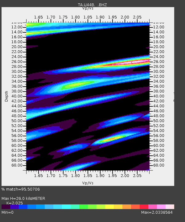
| Estimated Moho Depth: |
26.0 km |
| Estimated Crust Vp/Vs: |
2.03 |
| Assumed Crust Vp: |
6.444 km/s |
| Estimated Crust Vs: |
3.182 km/s |
| Estimated Crust Poisson's Ratio: |
0.34 |
|
| Radial Match: |
95.50706 % |
| Radial Bump: |
309 |
| Transverse Match: |
88.11019 % |
| Transverse Bump: |
400 |
| SOD ConfigId: |
440406 |
| Insert Time: |
2012-06-08 05:55:45.598 +0000 |
| GWidth: |
2.5 |
| Max Bumps: |
400 |
| Tol: |
0.001 |
|
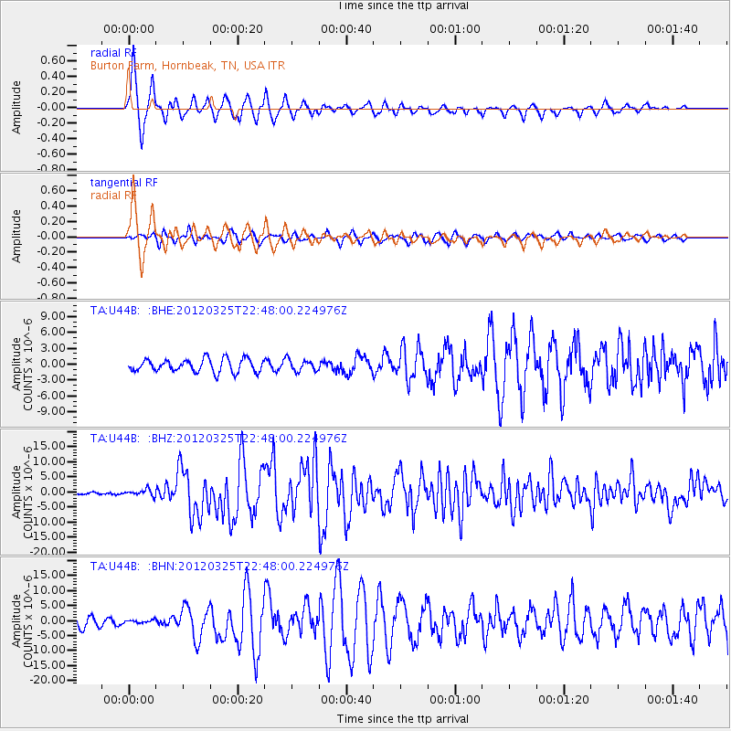
Signal To Noise
| Channel | StoN | STA | LTA |
| TA:U44B: :BHZ:20120325T22:48:00.224976Z | 4.177881 | 1.1118229E-6 | 2.6612128E-7 |
| TA:U44B: :BHN:20120325T22:48:00.224976Z | 0.3477767 | 5.51783E-7 | 1.5866013E-6 |
| TA:U44B: :BHE:20120325T22:48:00.224976Z | 0.8872569 | 1.0820668E-6 | 1.2195643E-6 |
| Arrivals |
| Ps | 4.3 SECOND |
| PpPs | 12 SECOND |
| PsPs/PpSs | 16 SECOND |


