You are here: Home > Network List > TA - USArray Transportable Network (new EarthScope stations) Stations List
> Station T42A Van Buren, MO, USA > Earthquake Result Viewer
T42A Van Buren, MO, USA - Earthquake Result Viewer
| Earthquake location: |
Near Coast Of Central Chile |
| Earthquake latitude/longitude: |
-35.2/-72.2 |
| Earthquake time(UTC): |
2012/03/25 (085) 22:37:06 GMT |
| Earthquake Depth: |
41 km |
| Earthquake Magnitude: |
6.5 MB, 7.0 MS, 7.1 MW, 7.1 MW |
| Earthquake Catalog/Contributor: |
WHDF/NEIC |
|
| Network: |
TA USArray Transportable Network (new EarthScope stations) |
| Station: |
T42A Van Buren, MO, USA |
| Lat/Lon: |
37.03 N/91.09 W |
| Elevation: |
162 m |
|
| Distance: |
74.0 deg |
| Az: |
344.374 deg |
| Baz: |
163.999 deg |
| Ray Param: |
0.05257452 |
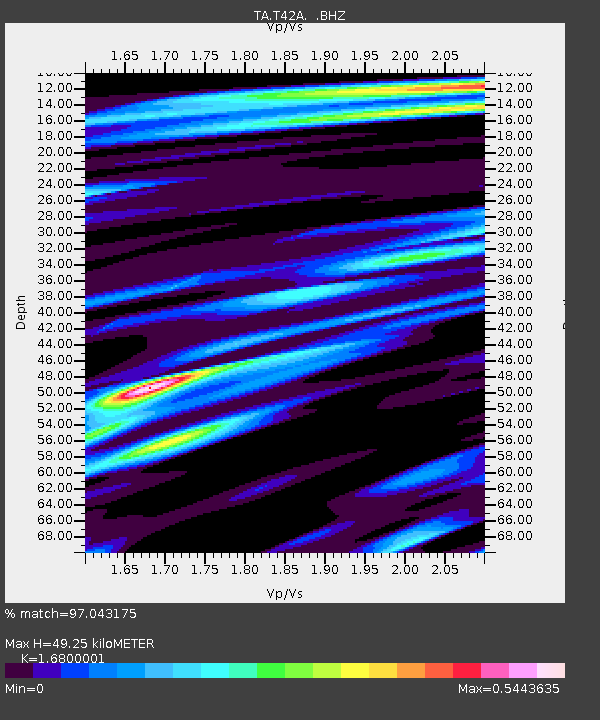
| Estimated Moho Depth: |
49.25 km |
| Estimated Crust Vp/Vs: |
1.68 |
| Assumed Crust Vp: |
6.53 km/s |
| Estimated Crust Vs: |
3.887 km/s |
| Estimated Crust Poisson's Ratio: |
0.23 |
|
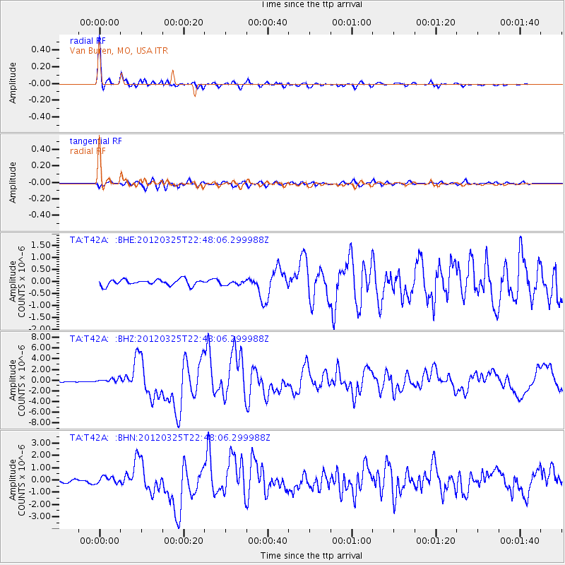
| Radial Match: |
97.043175 % |
| Radial Bump: |
304 |
| Transverse Match: |
92.119125 % |
| Transverse Bump: |
400 |
| SOD ConfigId: |
440406 |
| Insert Time: |
2012-06-08 05:56:56.126 +0000 |
| GWidth: |
2.5 |
| Max Bumps: |
400 |
| Tol: |
0.001 |
|
Signal To Noise
| Channel | StoN | STA | LTA |
| TA:T42A: :BHZ:20120325T22:48:06.299988Z | 2.7115915 | 4.2872506E-7 | 1.5810828E-7 |
| TA:T42A: :BHN:20120325T22:48:06.299988Z | 2.3141255 | 2.8012585E-7 | 1.210504E-7 |
| TA:T42A: :BHE:20120325T22:48:06.299988Z | 0.7094663 | 8.7221125E-8 | 1.2293907E-7 |
| Arrivals |
| Ps | 5.3 SECOND |
| PpPs | 19 SECOND |
| PsPs/PpSs | 25 SECOND |


