You are here: Home > Network List > ZJ12 - Transantarctic Mountains Northern Network Stations List
> Station SAMH East Antarctica > Earthquake Result Viewer
SAMH East Antarctica - Earthquake Result Viewer
| Earthquake location: |
South Of Fiji Islands |
| Earthquake latitude/longitude: |
-24.6/179.1 |
| Earthquake time(UTC): |
2014/05/04 (124) 09:15:53 GMT |
| Earthquake Depth: |
528 km |
| Earthquake Magnitude: |
6.6 MWP, 6.8 MI |
| Earthquake Catalog/Contributor: |
NEIC PDE/NEIC COMCAT |
|
| Network: |
ZJ Transantarctic Mountains Northern Network |
| Station: |
SAMH East Antarctica |
| Lat/Lon: |
75.20 S/154.00 E |
| Elevation: |
2087 m |
|
| Distance: |
52.2 deg |
| Az: |
187.924 deg |
| Baz: |
29.216 deg |
| Ray Param: |
0.06459443 |
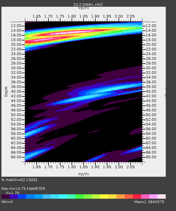
| Estimated Moho Depth: |
14.75 km |
| Estimated Crust Vp/Vs: |
1.78 |
| Assumed Crust Vp: |
6.262 km/s |
| Estimated Crust Vs: |
3.518 km/s |
| Estimated Crust Poisson's Ratio: |
0.27 |
|
| Radial Match: |
82.15081 % |
| Radial Bump: |
400 |
| Transverse Match: |
75.77966 % |
| Transverse Bump: |
386 |
| SOD ConfigId: |
3390531 |
| Insert Time: |
2019-04-11 16:58:23.626 +0000 |
| GWidth: |
2.5 |
| Max Bumps: |
400 |
| Tol: |
0.001 |
|

Signal To Noise
| Channel | StoN | STA | LTA |
| ZJ:SAMH: :HHZ:20140504T09:23:42.999993Z | 14.06978 | 2.9832484E-6 | 2.1203233E-7 |
| ZJ:SAMH: :HHN:20140504T09:23:42.999993Z | 4.3108964 | 8.0765216E-7 | 1.8735135E-7 |
| ZJ:SAMH: :HHE:20140504T09:23:42.999993Z | 2.6666965 | 7.073867E-7 | 2.6526703E-7 |
| Arrivals |
| Ps | 1.9 SECOND |
| PpPs | 6.2 SECOND |
| PsPs/PpSs | 8.2 SECOND |


