You are here: Home > Network List > TA - USArray Transportable Network (new EarthScope stations) Stations List
> Station F39A Loretta, WI, USA > Earthquake Result Viewer
F39A Loretta, WI, USA - Earthquake Result Viewer
| Earthquake location: |
Near Coast Of Central Chile |
| Earthquake latitude/longitude: |
-35.2/-72.2 |
| Earthquake time(UTC): |
2012/03/25 (085) 22:37:06 GMT |
| Earthquake Depth: |
41 km |
| Earthquake Magnitude: |
6.5 MB, 7.0 MS, 7.1 MW, 7.1 MW |
| Earthquake Catalog/Contributor: |
WHDF/NEIC |
|
| Network: |
TA USArray Transportable Network (new EarthScope stations) |
| Station: |
F39A Loretta, WI, USA |
| Lat/Lon: |
45.92 N/90.92 W |
| Elevation: |
440 m |
|
| Distance: |
82.5 deg |
| Az: |
346.951 deg |
| Baz: |
164.641 deg |
| Ray Param: |
0.046788525 |
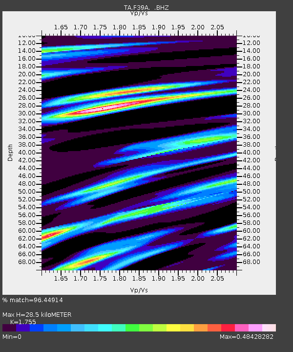
| Estimated Moho Depth: |
28.5 km |
| Estimated Crust Vp/Vs: |
1.75 |
| Assumed Crust Vp: |
6.571 km/s |
| Estimated Crust Vs: |
3.744 km/s |
| Estimated Crust Poisson's Ratio: |
0.26 |
|
| Radial Match: |
96.44914 % |
| Radial Bump: |
392 |
| Transverse Match: |
80.457245 % |
| Transverse Bump: |
400 |
| SOD ConfigId: |
440406 |
| Insert Time: |
2012-06-08 05:57:21.512 +0000 |
| GWidth: |
2.5 |
| Max Bumps: |
400 |
| Tol: |
0.001 |
|
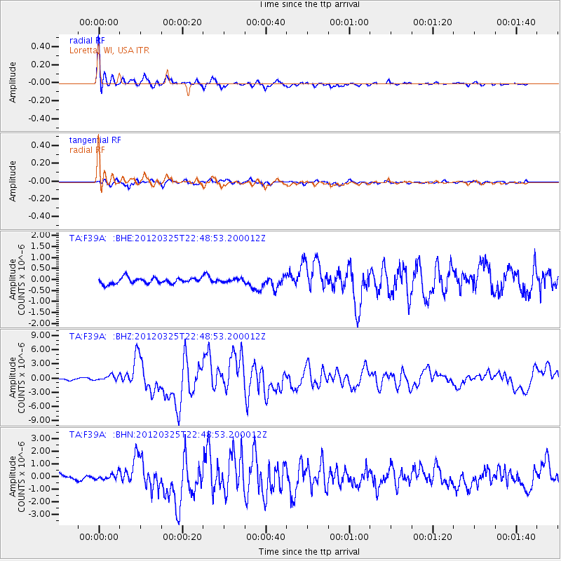
Signal To Noise
| Channel | StoN | STA | LTA |
| TA:F39A: :BHZ:20120325T22:48:53.200012Z | 3.0579436 | 5.745029E-7 | 1.8787232E-7 |
| TA:F39A: :BHN:20120325T22:48:53.200012Z | 1.5406578 | 2.475764E-7 | 1.6069527E-7 |
| TA:F39A: :BHE:20120325T22:48:53.200012Z | 0.58151263 | 7.6677544E-8 | 1.3185877E-7 |
| Arrivals |
| Ps | 3.4 SECOND |
| PpPs | 12 SECOND |
| PsPs/PpSs | 15 SECOND |


