You are here: Home > Network List > G - GEOSCOPE Stations List
> Station INU Inuyama, Japan > Earthquake Result Viewer
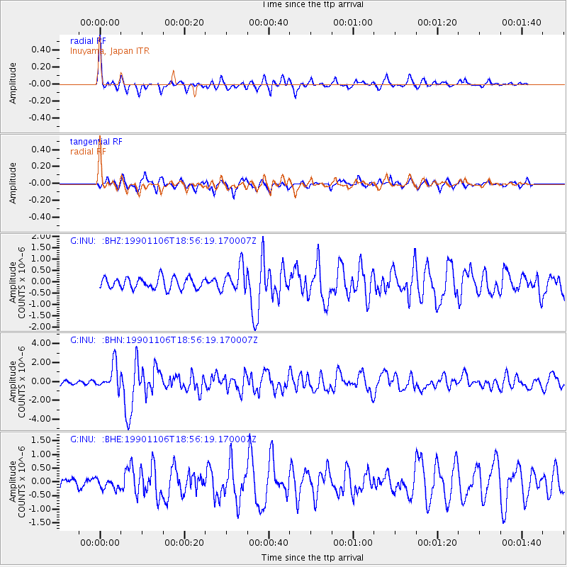
INU Inuyama, Japan - Earthquake Result Viewer
*The percent match for this event was below the threshold and hence no stack was calculated.
| Earthquake location: |
Southern Iran |
| Earthquake latitude/longitude: |
28.2/55.5 |
| Earthquake time(UTC): |
1990/11/06 (310) 18:45:54 GMT |
| Earthquake Depth: |
25 km |
| Earthquake Magnitude: |
6.2 MB, 6.8 MS, 6.7 UNKNOWN |
| Earthquake Catalog/Contributor: |
WHDF/NEIC |
|
| Network: |
G GEOSCOPE |
| Station: |
INU Inuyama, Japan |
| Lat/Lon: |
35.35 N/137.03 E |
| Elevation: |
132 m |
|
| Distance: |
67.9 deg |
| Az: |
60.805 deg |
| Baz: |
289.567 deg |
| Ray Param: |
$rayparam |
*The percent match for this event was below the threshold and hence was not used in the summary stack. |
|
| Radial Match: |
77.84072 % |
| Radial Bump: |
400 |
| Transverse Match: |
82.781845 % |
| Transverse Bump: |
400 |
| SOD ConfigId: |
4480 |
| Insert Time: |
2010-02-26 23:24:16.570 +0000 |
| GWidth: |
2.5 |
| Max Bumps: |
400 |
| Tol: |
0.001 |
|
Signal To Noise
| Channel | StoN | STA | LTA |
| G:INU: :BHN:19901106T18:56:19.170007Z | 7.835872 | 1.3758915E-6 | 1.7558882E-7 |
| G:INU: :BHE:19901106T18:56:19.170007Z | 1.3959904 | 1.8952959E-7 | 1.3576712E-7 |
| G:INU: :BHZ:19901106T18:56:19.170007Z | 2.3299575 | 5.634382E-7 | 2.418234E-7 |
| Arrivals |
| Ps | |
| PpPs | |
| PsPs/PpSs | |


