You are here: Home > Network List > TA - USArray Transportable Network (new EarthScope stations) Stations List
> Station Q45A Warren Harvey, Newton, IL, USA > Earthquake Result Viewer
Q45A Warren Harvey, Newton, IL, USA - Earthquake Result Viewer

| Earthquake location: |
Near Coast Of Central Chile |
| Earthquake latitude/longitude: |
-35.2/-72.2 |
| Earthquake time(UTC): |
2012/03/25 (085) 22:37:06 GMT |
| Earthquake Depth: |
41 km |
| Earthquake Magnitude: |
6.5 MB, 7.0 MS, 7.1 MW, 7.1 MW |
| Earthquake Catalog/Contributor: |
WHDF/NEIC |
|
| Network: |
TA USArray Transportable Network (new EarthScope stations) |
| Station: |
Q45A Warren Harvey, Newton, IL, USA |
| Lat/Lon: |
38.89 N/88.16 W |
| Elevation: |
162 m |
|
| Distance: |
75.2 deg |
| Az: |
347.193 deg |
| Baz: |
166.548 deg |
| Ray Param: |
0.051770564 |
| Estimated Moho Depth: |
37.75 km |
| Estimated Crust Vp/Vs: |
1.97 |
| Assumed Crust Vp: |
6.444 km/s |
| Estimated Crust Vs: |
3.279 km/s |
| Estimated Crust Poisson's Ratio: |
0.33 |
|
| Radial Match: |
94.55364 % |
| Radial Bump: |
343 |
| Transverse Match: |
86.78991 % |
| Transverse Bump: |
400 |
| SOD ConfigId: |
440406 |
| Insert Time: |
2012-06-08 05:59:12.017 +0000 |
| GWidth: |
2.5 |
| Max Bumps: |
400 |
| Tol: |
0.001 |
|
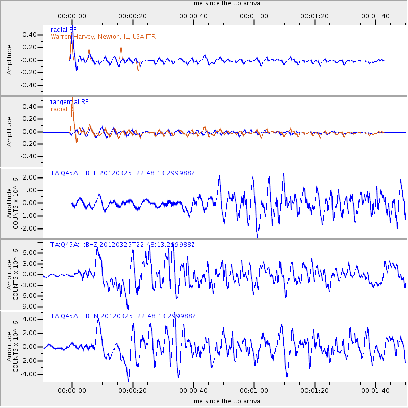
Signal To Noise
| Channel | StoN | STA | LTA |
| TA:Q45A: :BHZ:20120325T22:48:13.299988Z | 3.434608 | 6.97785E-7 | 2.0316293E-7 |
| TA:Q45A: :BHN:20120325T22:48:13.299988Z | 1.1028017 | 3.1009046E-7 | 2.8118427E-7 |
| TA:Q45A: :BHE:20120325T22:48:13.299988Z | 0.43009982 | 1.1271448E-7 | 2.6206587E-7 |
| Arrivals |
| Ps | 5.8 SECOND |
| PpPs | 17 SECOND |
| PsPs/PpSs | 23 SECOND |


