You are here: Home > Network List > TA - USArray Transportable Network (new EarthScope stations) Stations List
> Station T47A Sharon Grove, KY, USA > Earthquake Result Viewer
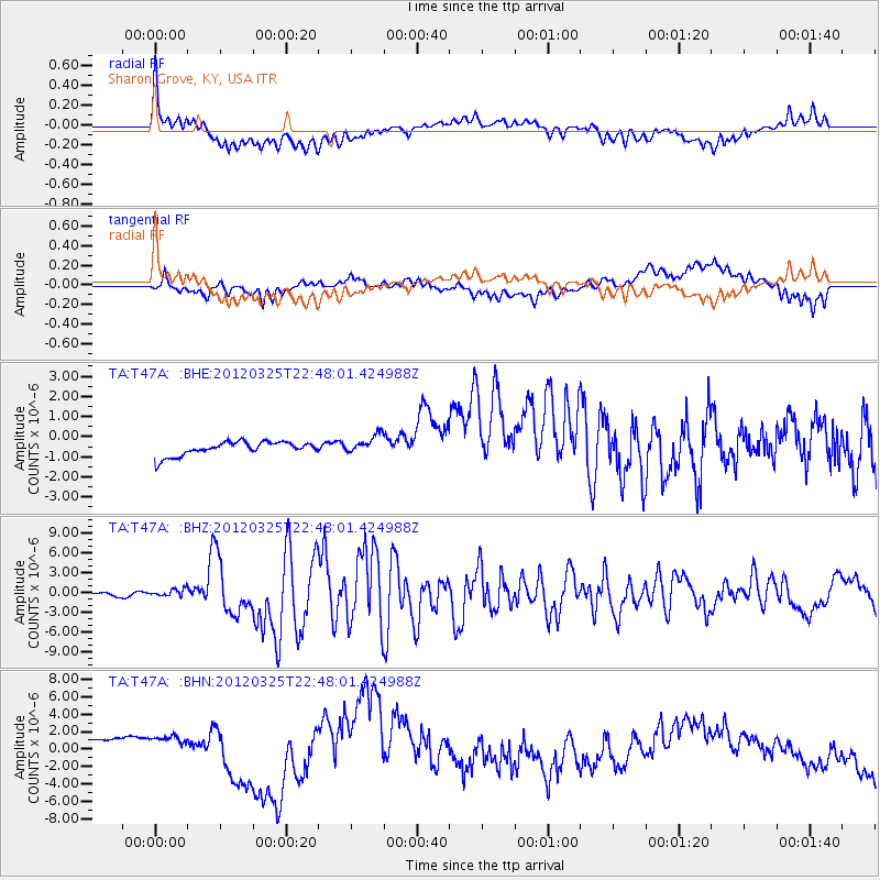
T47A Sharon Grove, KY, USA - Earthquake Result Viewer
*The percent match for this event was below the threshold and hence no stack was calculated.
| Earthquake location: |
Near Coast Of Central Chile |
| Earthquake latitude/longitude: |
-35.2/-72.2 |
| Earthquake time(UTC): |
2012/03/25 (085) 22:37:06 GMT |
| Earthquake Depth: |
41 km |
| Earthquake Magnitude: |
6.5 MB, 7.0 MS, 7.1 MW, 7.1 MW |
| Earthquake Catalog/Contributor: |
WHDF/NEIC |
|
| Network: |
TA USArray Transportable Network (new EarthScope stations) |
| Station: |
T47A Sharon Grove, KY, USA |
| Lat/Lon: |
36.99 N/87.11 W |
| Elevation: |
217 m |
|
| Distance: |
73.1 deg |
| Az: |
347.587 deg |
| Baz: |
167.299 deg |
| Ray Param: |
$rayparam |
*The percent match for this event was below the threshold and hence was not used in the summary stack. |
|
| Radial Match: |
41.002983 % |
| Radial Bump: |
400 |
| Transverse Match: |
56.98973 % |
| Transverse Bump: |
400 |
| SOD ConfigId: |
440406 |
| Insert Time: |
2012-06-08 06:00:01.606 +0000 |
| GWidth: |
2.5 |
| Max Bumps: |
400 |
| Tol: |
0.001 |
|
Signal To Noise
| Channel | StoN | STA | LTA |
| TA:T47A: :BHZ:20120325T22:48:01.424988Z | 2.4603398 | 5.725589E-7 | 2.3271538E-7 |
| TA:T47A: :BHN:20120325T22:48:01.424988Z | 1.0133818 | 3.5449154E-6 | 3.4981044E-6 |
| TA:T47A: :BHE:20120325T22:48:01.424988Z | 1.3581598 | 4.6619107E-7 | 3.43252E-7 |
| Arrivals |
| Ps | |
| PpPs | |
| PsPs/PpSs | |


