You are here: Home > Network List > TA - USArray Transportable Network (new EarthScope stations) Stations List
> Station 151A Opelika, AL, USA > Earthquake Result Viewer
151A Opelika, AL, USA - Earthquake Result Viewer
| Earthquake location: |
Near Coast Of Central Chile |
| Earthquake latitude/longitude: |
-35.2/-72.2 |
| Earthquake time(UTC): |
2012/03/25 (085) 22:37:06 GMT |
| Earthquake Depth: |
41 km |
| Earthquake Magnitude: |
6.5 MB, 7.0 MS, 7.1 MW, 7.1 MW |
| Earthquake Catalog/Contributor: |
WHDF/NEIC |
|
| Network: |
TA USArray Transportable Network (new EarthScope stations) |
| Station: |
151A Opelika, AL, USA |
| Lat/Lon: |
32.53 N/85.33 W |
| Elevation: |
211 m |
|
| Distance: |
68.5 deg |
| Az: |
348.115 deg |
| Baz: |
168.483 deg |
| Ray Param: |
0.056199595 |
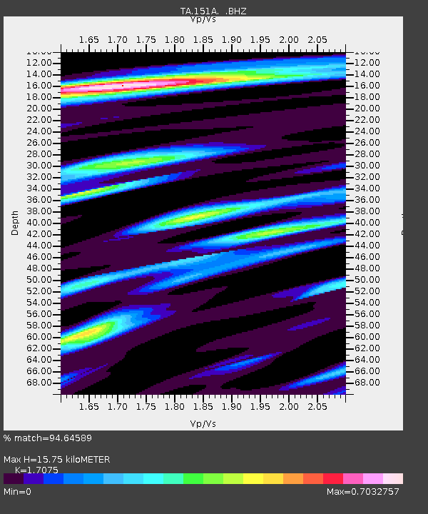
| Estimated Moho Depth: |
15.75 km |
| Estimated Crust Vp/Vs: |
1.71 |
| Assumed Crust Vp: |
6.719 km/s |
| Estimated Crust Vs: |
3.935 km/s |
| Estimated Crust Poisson's Ratio: |
0.24 |
|
| Radial Match: |
94.64589 % |
| Radial Bump: |
330 |
| Transverse Match: |
75.8027 % |
| Transverse Bump: |
400 |
| SOD ConfigId: |
440406 |
| Insert Time: |
2012-06-08 06:03:31.534 +0000 |
| GWidth: |
2.5 |
| Max Bumps: |
400 |
| Tol: |
0.001 |
|
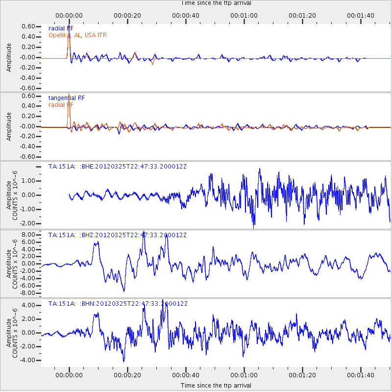
Signal To Noise
| Channel | StoN | STA | LTA |
| TA:151A: :BHZ:20120325T22:47:33.200012Z | 2.2480085 | 5.3638854E-7 | 2.3860608E-7 |
| TA:151A: :BHN:20120325T22:47:33.200012Z | 2.0092843 | 2.9450104E-7 | 1.4657012E-7 |
| TA:151A: :BHE:20120325T22:47:33.200012Z | 1.4331629 | 2.3470605E-7 | 1.6376788E-7 |
| Arrivals |
| Ps | 1.7 SECOND |
| PpPs | 6.1 SECOND |
| PsPs/PpSs | 7.8 SECOND |


