You are here: Home > Network List > TA - USArray Transportable Network (new EarthScope stations) Stations List
> Station C35A Jirik Farms, Max, MN, USA > Earthquake Result Viewer
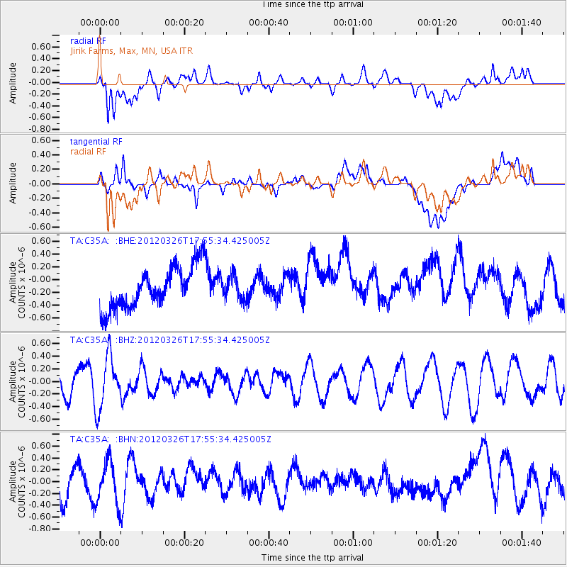
C35A Jirik Farms, Max, MN, USA - Earthquake Result Viewer
*The percent match for this event was below the threshold and hence no stack was calculated.
| Earthquake location: |
Northern East Pacific Rise |
| Earthquake latitude/longitude: |
10.0/-104.2 |
| Earthquake time(UTC): |
2012/03/26 (086) 17:48:42 GMT |
| Earthquake Depth: |
10 km |
| Earthquake Magnitude: |
5.5 MW, 5.3 MS, 5.1 MB |
| Earthquake Catalog/Contributor: |
WHDF/NEIC |
|
| Network: |
TA USArray Transportable Network (new EarthScope stations) |
| Station: |
C35A Jirik Farms, Max, MN, USA |
| Lat/Lon: |
47.70 N/93.98 W |
| Elevation: |
426 m |
|
| Distance: |
38.6 deg |
| Az: |
11.118 deg |
| Baz: |
196.332 deg |
| Ray Param: |
$rayparam |
*The percent match for this event was below the threshold and hence was not used in the summary stack. |
|
| Radial Match: |
64.27862 % |
| Radial Bump: |
400 |
| Transverse Match: |
58.26672 % |
| Transverse Bump: |
400 |
| SOD ConfigId: |
440406 |
| Insert Time: |
2012-06-08 06:35:53.617 +0000 |
| GWidth: |
2.5 |
| Max Bumps: |
400 |
| Tol: |
0.001 |
|
Signal To Noise
| Channel | StoN | STA | LTA |
| TA:C35A: :BHZ:20120326T17:55:34.425005Z | 2.3585067 | 4.2573723E-7 | 1.8051134E-7 |
| TA:C35A: :BHN:20120326T17:55:34.425005Z | 1.6646173 | 3.6582796E-7 | 2.19767E-7 |
| TA:C35A: :BHE:20120326T17:55:34.425005Z | 0.5734573 | 1.8384769E-7 | 3.2059523E-7 |
| Arrivals |
| Ps | |
| PpPs | |
| PsPs/PpSs | |


