You are here: Home > Network List > TA - USArray Transportable Network (new EarthScope stations) Stations List
> Station C36A Pine Crest Fram, Angora, MN, USA > Earthquake Result Viewer
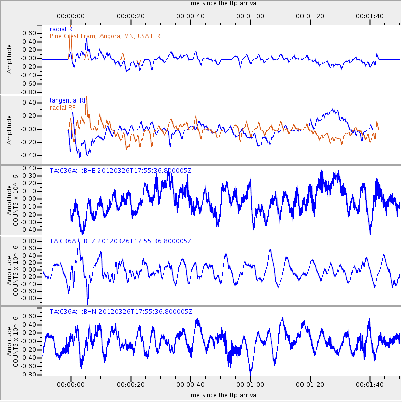
C36A Pine Crest Fram, Angora, MN, USA - Earthquake Result Viewer
*The percent match for this event was below the threshold and hence no stack was calculated.
| Earthquake location: |
Northern East Pacific Rise |
| Earthquake latitude/longitude: |
10.0/-104.2 |
| Earthquake time(UTC): |
2012/03/26 (086) 17:48:42 GMT |
| Earthquake Depth: |
10 km |
| Earthquake Magnitude: |
5.5 MW, 5.3 MS, 5.1 MB |
| Earthquake Catalog/Contributor: |
WHDF/NEIC |
|
| Network: |
TA USArray Transportable Network (new EarthScope stations) |
| Station: |
C36A Pine Crest Fram, Angora, MN, USA |
| Lat/Lon: |
47.76 N/92.84 W |
| Elevation: |
410 m |
|
| Distance: |
38.8 deg |
| Az: |
12.265 deg |
| Baz: |
198.067 deg |
| Ray Param: |
$rayparam |
*The percent match for this event was below the threshold and hence was not used in the summary stack. |
|
| Radial Match: |
59.65136 % |
| Radial Bump: |
400 |
| Transverse Match: |
64.01468 % |
| Transverse Bump: |
400 |
| SOD ConfigId: |
440406 |
| Insert Time: |
2012-06-08 06:36:07.907 +0000 |
| GWidth: |
2.5 |
| Max Bumps: |
400 |
| Tol: |
0.001 |
|
Signal To Noise
| Channel | StoN | STA | LTA |
| TA:C36A: :BHZ:20120326T17:55:36.800005Z | 2.2782063 | 4.1603386E-7 | 1.8261466E-7 |
| TA:C36A: :BHN:20120326T17:55:36.800005Z | 1.1878289 | 3.0130647E-7 | 2.536615E-7 |
| TA:C36A: :BHE:20120326T17:55:36.800005Z | 2.3798554 | 3.015568E-7 | 1.2671224E-7 |
| Arrivals |
| Ps | |
| PpPs | |
| PsPs/PpSs | |


