You are here: Home > Network List > UW - Pacific Northwest Regional Seismic Network Stations List
> Station UMAT Pilot Rock, OR, USA > Earthquake Result Viewer
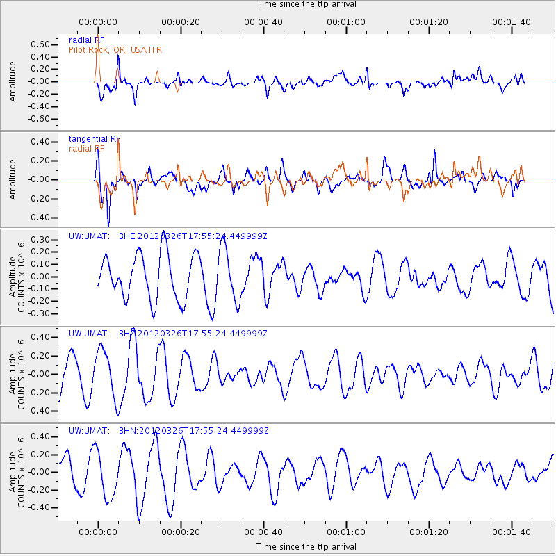
UMAT Pilot Rock, OR, USA - Earthquake Result Viewer
*The percent match for this event was below the threshold and hence no stack was calculated.
| Earthquake location: |
Northern East Pacific Rise |
| Earthquake latitude/longitude: |
10.0/-104.2 |
| Earthquake time(UTC): |
2012/03/26 (086) 17:48:42 GMT |
| Earthquake Depth: |
10 km |
| Earthquake Magnitude: |
5.5 MW, 5.3 MS, 5.1 MB |
| Earthquake Catalog/Contributor: |
WHDF/NEIC |
|
| Network: |
UW Pacific Northwest Regional Seismic Network |
| Station: |
UMAT Pilot Rock, OR, USA |
| Lat/Lon: |
45.29 N/118.96 W |
| Elevation: |
1318 m |
|
| Distance: |
37.4 deg |
| Az: |
342.803 deg |
| Baz: |
155.634 deg |
| Ray Param: |
$rayparam |
*The percent match for this event was below the threshold and hence was not used in the summary stack. |
|
| Radial Match: |
79.49641 % |
| Radial Bump: |
400 |
| Transverse Match: |
66.029976 % |
| Transverse Bump: |
400 |
| SOD ConfigId: |
440406 |
| Insert Time: |
2012-06-08 06:38:55.408 +0000 |
| GWidth: |
2.5 |
| Max Bumps: |
400 |
| Tol: |
0.001 |
|
Signal To Noise
| Channel | StoN | STA | LTA |
| UW:UMAT: :BHZ:20120326T17:55:24.449999Z | 1.6233304 | 2.5611166E-7 | 1.5776926E-7 |
| UW:UMAT: :BHN:20120326T17:55:24.449999Z | 1.8124666 | 2.6224868E-7 | 1.446916E-7 |
| UW:UMAT: :BHE:20120326T17:55:24.449999Z | 1.1869199 | 2.1345146E-7 | 1.7983643E-7 |
| Arrivals |
| Ps | |
| PpPs | |
| PsPs/PpSs | |


