You are here: Home > Network List > TA - USArray Transportable Network (new EarthScope stations) Stations List
> Station D34A Park Rapids, MN, USA > Earthquake Result Viewer
D34A Park Rapids, MN, USA - Earthquake Result Viewer
| Earthquake location: |
Northern East Pacific Rise |
| Earthquake latitude/longitude: |
10.1/-104.2 |
| Earthquake time(UTC): |
2012/03/26 (086) 18:12:52 GMT |
| Earthquake Depth: |
10 km |
| Earthquake Magnitude: |
5.6 MB, 5.8 MS, 6.0 MW, 6.0 MW |
| Earthquake Catalog/Contributor: |
WHDF/NEIC |
|
| Network: |
TA USArray Transportable Network (new EarthScope stations) |
| Station: |
D34A Park Rapids, MN, USA |
| Lat/Lon: |
47.09 N/95.20 W |
| Elevation: |
476 m |
|
| Distance: |
37.7 deg |
| Az: |
10.036 deg |
| Baz: |
194.545 deg |
| Ray Param: |
0.07600926 |
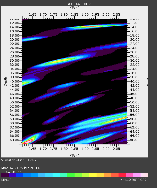
| Estimated Moho Depth: |
68.75 km |
| Estimated Crust Vp/Vs: |
1.63 |
| Assumed Crust Vp: |
6.419 km/s |
| Estimated Crust Vs: |
3.944 km/s |
| Estimated Crust Poisson's Ratio: |
0.20 |
|
| Radial Match: |
80.331245 % |
| Radial Bump: |
400 |
| Transverse Match: |
49.98649 % |
| Transverse Bump: |
400 |
| SOD ConfigId: |
440406 |
| Insert Time: |
2012-06-08 06:57:28.488 +0000 |
| GWidth: |
2.5 |
| Max Bumps: |
400 |
| Tol: |
0.001 |
|

Signal To Noise
| Channel | StoN | STA | LTA |
| TA:D34A: :BHZ:20120326T18:19:37.274988Z | 2.1708057 | 9.434162E-7 | 4.3459264E-7 |
| TA:D34A: :BHN:20120326T18:19:37.274988Z | 1.9940999 | 8.345967E-7 | 4.1853306E-7 |
| TA:D34A: :BHE:20120326T18:19:37.274988Z | 1.3715669 | 6.553899E-7 | 4.778403E-7 |
| Arrivals |
| Ps | 7.3 SECOND |
| PpPs | 26 SECOND |
| PsPs/PpSs | 33 SECOND |


