You are here: Home > Network List > TA - USArray Transportable Network (new EarthScope stations) Stations List
> Station A33A Warroad, MN, USA > Earthquake Result Viewer
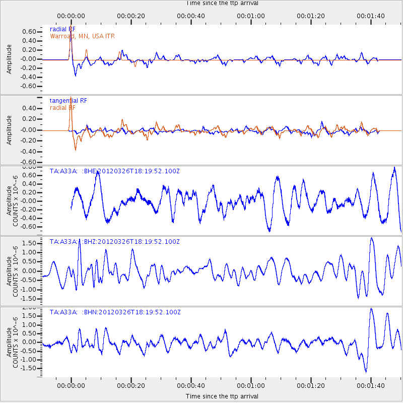
A33A Warroad, MN, USA - Earthquake Result Viewer
*The percent match for this event was below the threshold and hence no stack was calculated.
| Earthquake location: |
Northern East Pacific Rise |
| Earthquake latitude/longitude: |
10.1/-104.2 |
| Earthquake time(UTC): |
2012/03/26 (086) 18:12:52 GMT |
| Earthquake Depth: |
10 km |
| Earthquake Magnitude: |
5.6 MB, 5.8 MS, 6.0 MW, 6.0 MW |
| Earthquake Catalog/Contributor: |
WHDF/NEIC |
|
| Network: |
TA USArray Transportable Network (new EarthScope stations) |
| Station: |
A33A Warroad, MN, USA |
| Lat/Lon: |
48.94 N/95.39 W |
| Elevation: |
329 m |
|
| Distance: |
39.4 deg |
| Az: |
9.107 deg |
| Baz: |
193.673 deg |
| Ray Param: |
$rayparam |
*The percent match for this event was below the threshold and hence was not used in the summary stack. |
|
| Radial Match: |
65.56997 % |
| Radial Bump: |
320 |
| Transverse Match: |
47.683784 % |
| Transverse Bump: |
324 |
| SOD ConfigId: |
440406 |
| Insert Time: |
2012-06-08 06:59:25.880 +0000 |
| GWidth: |
2.5 |
| Max Bumps: |
400 |
| Tol: |
0.001 |
|
Signal To Noise
| Channel | StoN | STA | LTA |
| TA:A33A: :BHZ:20120326T18:19:52.100Z | 1.849564 | 7.0067637E-7 | 3.7883328E-7 |
| TA:A33A: :BHN:20120326T18:19:52.100Z | 1.9898189 | 3.5887786E-7 | 1.8035705E-7 |
| TA:A33A: :BHE:20120326T18:19:52.100Z | 0.9880748 | 2.6158236E-7 | 2.6473944E-7 |
| Arrivals |
| Ps | |
| PpPs | |
| PsPs/PpSs | |


