You are here: Home > Network List > TA - USArray Transportable Network (new EarthScope stations) Stations List
> Station S44A Carbondale, IL, USA > Earthquake Result Viewer
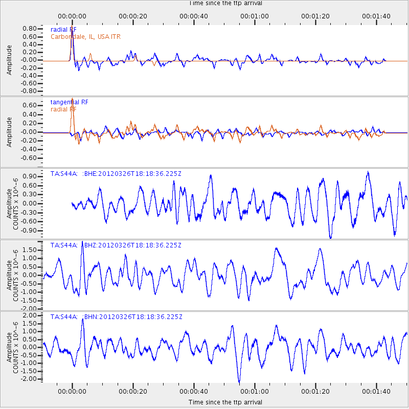
S44A Carbondale, IL, USA - Earthquake Result Viewer

| Earthquake location: |
Northern East Pacific Rise |
| Earthquake latitude/longitude: |
10.1/-104.2 |
| Earthquake time(UTC): |
2012/03/26 (086) 18:12:52 GMT |
| Earthquake Depth: |
10 km |
| Earthquake Magnitude: |
5.6 MB, 5.8 MS, 6.0 MW, 6.0 MW |
| Earthquake Catalog/Contributor: |
WHDF/NEIC |
|
| Network: |
TA USArray Transportable Network (new EarthScope stations) |
| Station: |
S44A Carbondale, IL, USA |
| Lat/Lon: |
37.69 N/89.26 W |
| Elevation: |
155 m |
|
| Distance: |
30.6 deg |
| Az: |
23.627 deg |
| Baz: |
209.838 deg |
| Ray Param: |
0.07928842 |
| Estimated Moho Depth: |
58.5 km |
| Estimated Crust Vp/Vs: |
2.09 |
| Assumed Crust Vp: |
6.444 km/s |
| Estimated Crust Vs: |
3.091 km/s |
| Estimated Crust Poisson's Ratio: |
0.35 |
|
| Radial Match: |
80.47331 % |
| Radial Bump: |
400 |
| Transverse Match: |
53.166355 % |
| Transverse Bump: |
400 |
| SOD ConfigId: |
440406 |
| Insert Time: |
2012-06-08 07:03:00.756 +0000 |
| GWidth: |
2.5 |
| Max Bumps: |
400 |
| Tol: |
0.001 |
|
Signal To Noise
| Channel | StoN | STA | LTA |
| TA:S44A: :BHZ:20120326T18:18:36.225Z | 3.1347017 | 9.4355994E-7 | 3.010047E-7 |
| TA:S44A: :BHN:20120326T18:18:36.225Z | 3.0303814 | 8.7646504E-7 | 2.8922597E-7 |
| TA:S44A: :BHE:20120326T18:18:36.225Z | 1.2938557 | 3.2987626E-7 | 2.5495598E-7 |
| Arrivals |
| Ps | 11 SECOND |
| PpPs | 26 SECOND |
| PsPs/PpSs | 37 SECOND |


