You are here: Home > Network List > TA - USArray Transportable Network (new EarthScope stations) Stations List
> Station G43A Wallace, MI, USA > Earthquake Result Viewer
G43A Wallace, MI, USA - Earthquake Result Viewer
*The percent match for this event was below the threshold and hence no stack was calculated.
| Earthquake location: |
Northern East Pacific Rise |
| Earthquake latitude/longitude: |
10.1/-104.2 |
| Earthquake time(UTC): |
2012/03/26 (086) 18:12:52 GMT |
| Earthquake Depth: |
10 km |
| Earthquake Magnitude: |
5.6 MB, 5.8 MS, 6.0 MW, 6.0 MW |
| Earthquake Catalog/Contributor: |
WHDF/NEIC |
|
| Network: |
TA USArray Transportable Network (new EarthScope stations) |
| Station: |
G43A Wallace, MI, USA |
| Lat/Lon: |
45.26 N/87.69 W |
| Elevation: |
213 m |
|
| Distance: |
37.8 deg |
| Az: |
19.068 deg |
| Baz: |
207.097 deg |
| Ray Param: |
$rayparam |
*The percent match for this event was below the threshold and hence was not used in the summary stack. |
|
| Radial Match: |
79.99244 % |
| Radial Bump: |
306 |
| Transverse Match: |
49.044315 % |
| Transverse Bump: |
400 |
| SOD ConfigId: |
440406 |
| Insert Time: |
2012-06-08 07:06:57.186 +0000 |
| GWidth: |
2.5 |
| Max Bumps: |
400 |
| Tol: |
0.001 |
|
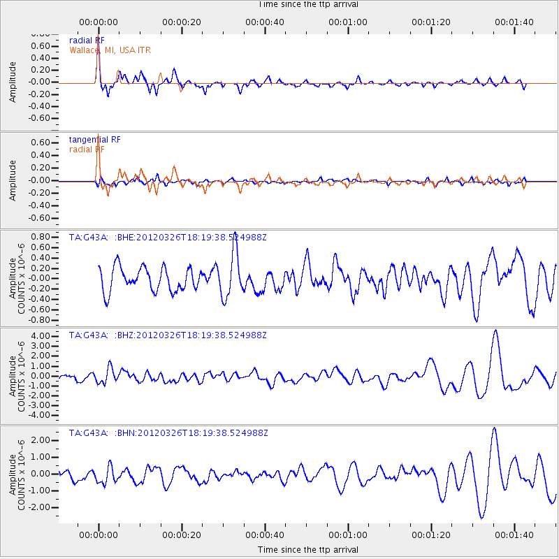
Signal To Noise
| Channel | StoN | STA | LTA |
| TA:G43A: :BHZ:20120326T18:19:38.524988Z | 3.1469595 | 7.4715456E-7 | 2.3742109E-7 |
| TA:G43A: :BHN:20120326T18:19:38.524988Z | 1.7275773 | 5.0919886E-7 | 2.9474734E-7 |
| TA:G43A: :BHE:20120326T18:19:38.524988Z | 1.9720576 | 4.4707673E-7 | 2.2670572E-7 |
| Arrivals |
| Ps | |
| PpPs | |
| PsPs/PpSs | |


