You are here: Home > Network List > TA - USArray Transportable Network (new EarthScope stations) Stations List
> Station H42A Shiocton, WI, USA > Earthquake Result Viewer
H42A Shiocton, WI, USA - Earthquake Result Viewer
| Earthquake location: |
Northern East Pacific Rise |
| Earthquake latitude/longitude: |
10.1/-104.2 |
| Earthquake time(UTC): |
2012/03/26 (086) 18:12:52 GMT |
| Earthquake Depth: |
10 km |
| Earthquake Magnitude: |
5.6 MB, 5.8 MS, 6.0 MW, 6.0 MW |
| Earthquake Catalog/Contributor: |
WHDF/NEIC |
|
| Network: |
TA USArray Transportable Network (new EarthScope stations) |
| Station: |
H42A Shiocton, WI, USA |
| Lat/Lon: |
44.51 N/88.53 W |
| Elevation: |
244 m |
|
| Distance: |
36.9 deg |
| Az: |
18.736 deg |
| Baz: |
206.239 deg |
| Ray Param: |
0.07644176 |
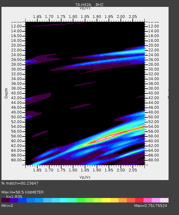
| Estimated Moho Depth: |
58.5 km |
| Estimated Crust Vp/Vs: |
1.93 |
| Assumed Crust Vp: |
6.41 km/s |
| Estimated Crust Vs: |
3.313 km/s |
| Estimated Crust Poisson's Ratio: |
0.32 |
|
| Radial Match: |
80.23647 % |
| Radial Bump: |
357 |
| Transverse Match: |
66.55104 % |
| Transverse Bump: |
337 |
| SOD ConfigId: |
440406 |
| Insert Time: |
2012-06-08 07:07:36.922 +0000 |
| GWidth: |
2.5 |
| Max Bumps: |
400 |
| Tol: |
0.001 |
|

Signal To Noise
| Channel | StoN | STA | LTA |
| TA:H42A: :BHZ:20120326T18:19:30.575006Z | 2.6845026 | 1.1176998E-6 | 4.1635263E-7 |
| TA:H42A: :BHN:20120326T18:19:30.575006Z | 1.917853 | 8.032628E-7 | 4.188344E-7 |
| TA:H42A: :BHE:20120326T18:19:30.575006Z | 1.1436822 | 5.257065E-7 | 4.5966138E-7 |
| Arrivals |
| Ps | 9.1 SECOND |
| PpPs | 25 SECOND |
| PsPs/PpSs | 34 SECOND |


