You are here: Home > Network List > TA - USArray Transportable Network (new EarthScope stations) Stations List
> Station N45A Kentland, IN, USA > Earthquake Result Viewer
N45A Kentland, IN, USA - Earthquake Result Viewer
| Earthquake location: |
Northern East Pacific Rise |
| Earthquake latitude/longitude: |
10.1/-104.2 |
| Earthquake time(UTC): |
2012/03/26 (086) 18:12:52 GMT |
| Earthquake Depth: |
10 km |
| Earthquake Magnitude: |
5.6 MB, 5.8 MS, 6.0 MW, 6.0 MW |
| Earthquake Catalog/Contributor: |
WHDF/NEIC |
|
| Network: |
TA USArray Transportable Network (new EarthScope stations) |
| Station: |
N45A Kentland, IN, USA |
| Lat/Lon: |
40.85 N/87.51 W |
| Elevation: |
206 m |
|
| Distance: |
34.0 deg |
| Az: |
22.866 deg |
| Baz: |
210.294 deg |
| Ray Param: |
0.07794501 |
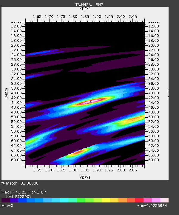
| Estimated Moho Depth: |
43.25 km |
| Estimated Crust Vp/Vs: |
1.87 |
| Assumed Crust Vp: |
6.498 km/s |
| Estimated Crust Vs: |
3.47 km/s |
| Estimated Crust Poisson's Ratio: |
0.30 |
|
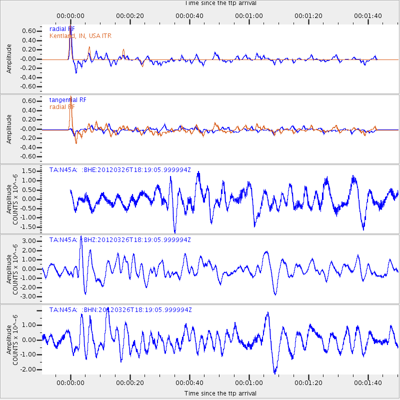
| Radial Match: |
81.86308 % |
| Radial Bump: |
288 |
| Transverse Match: |
43.82124 % |
| Transverse Bump: |
349 |
| SOD ConfigId: |
440406 |
| Insert Time: |
2012-06-08 07:08:17.640 +0000 |
| GWidth: |
2.5 |
| Max Bumps: |
400 |
| Tol: |
0.001 |
|
Signal To Noise
| Channel | StoN | STA | LTA |
| TA:N45A: :BHZ:20120326T18:19:05.999994Z | 3.54849 | 1.4029476E-6 | 3.953647E-7 |
| TA:N45A: :BHN:20120326T18:19:05.999994Z | 2.9764326 | 8.271772E-7 | 2.7790892E-7 |
| TA:N45A: :BHE:20120326T18:19:05.999994Z | 2.269084 | 6.366105E-7 | 2.8055837E-7 |
| Arrivals |
| Ps | 6.3 SECOND |
| PpPs | 18 SECOND |
| PsPs/PpSs | 24 SECOND |


