You are here: Home > Network List > TA - USArray Transportable Network (new EarthScope stations) Stations List
> Station I43A Langenfeld Brothers Farm, Elkhart Lake, WI, USA > Earthquake Result Viewer
I43A Langenfeld Brothers Farm, Elkhart Lake, WI, USA - Earthquake Result Viewer
| Earthquake location: |
Northern East Pacific Rise |
| Earthquake latitude/longitude: |
10.1/-104.2 |
| Earthquake time(UTC): |
2012/03/26 (086) 18:12:52 GMT |
| Earthquake Depth: |
10 km |
| Earthquake Magnitude: |
5.6 MB, 5.8 MS, 6.0 MW, 6.0 MW |
| Earthquake Catalog/Contributor: |
WHDF/NEIC |
|
| Network: |
TA USArray Transportable Network (new EarthScope stations) |
| Station: |
I43A Langenfeld Brothers Farm, Elkhart Lake, WI, USA |
| Lat/Lon: |
43.88 N/88.15 W |
| Elevation: |
299 m |
|
| Distance: |
36.4 deg |
| Az: |
19.621 deg |
| Baz: |
207.216 deg |
| Ray Param: |
0.076677784 |
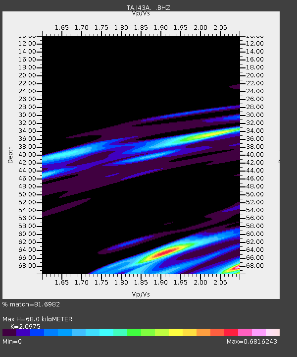
| Estimated Moho Depth: |
68.0 km |
| Estimated Crust Vp/Vs: |
2.10 |
| Assumed Crust Vp: |
6.571 km/s |
| Estimated Crust Vs: |
3.133 km/s |
| Estimated Crust Poisson's Ratio: |
0.35 |
|
| Radial Match: |
81.6982 % |
| Radial Bump: |
306 |
| Transverse Match: |
63.867466 % |
| Transverse Bump: |
302 |
| SOD ConfigId: |
440406 |
| Insert Time: |
2012-06-08 07:09:18.281 +0000 |
| GWidth: |
2.5 |
| Max Bumps: |
400 |
| Tol: |
0.001 |
|
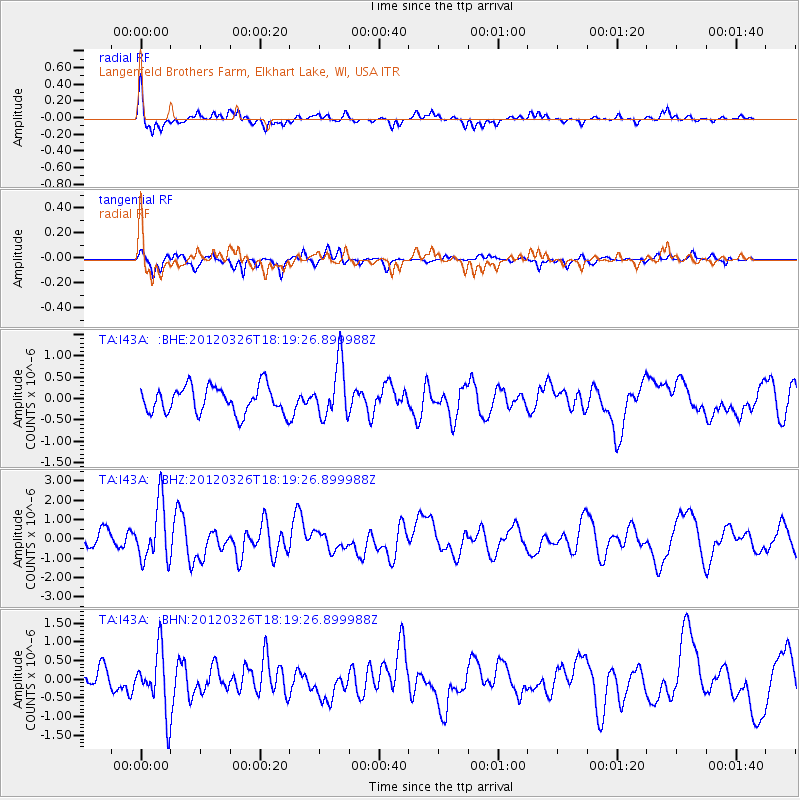
Signal To Noise
| Channel | StoN | STA | LTA |
| TA:I43A: :BHZ:20120326T18:19:26.899988Z | 3.3766053 | 1.486382E-6 | 4.4020007E-7 |
| TA:I43A: :BHN:20120326T18:19:26.899988Z | 3.7034986 | 8.0828653E-7 | 2.1824945E-7 |
| TA:I43A: :BHE:20120326T18:19:26.899988Z | 2.0391045 | 6.377448E-7 | 3.1275727E-7 |
| Arrivals |
| Ps | 12 SECOND |
| PpPs | 30 SECOND |
| PsPs/PpSs | 42 SECOND |


