You are here: Home > Network List > TA - USArray Transportable Network (new EarthScope stations) Stations List
> Station M43A Waltham Township, Utica, IL, USA > Earthquake Result Viewer
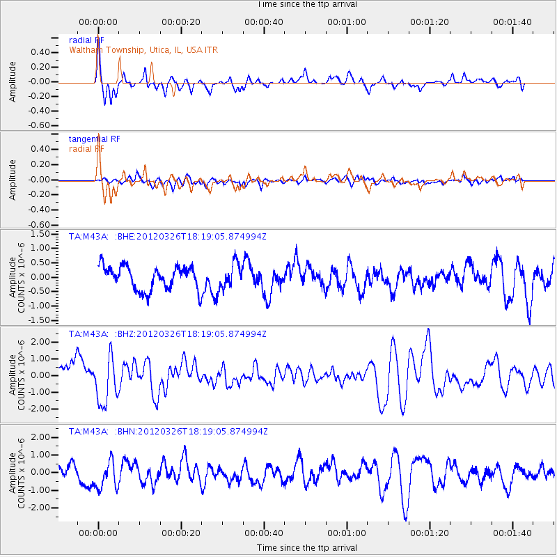
M43A Waltham Township, Utica, IL, USA - Earthquake Result Viewer
*The percent match for this event was below the threshold and hence no stack was calculated.
| Earthquake location: |
Northern East Pacific Rise |
| Earthquake latitude/longitude: |
10.1/-104.2 |
| Earthquake time(UTC): |
2012/03/26 (086) 18:12:52 GMT |
| Earthquake Depth: |
10 km |
| Earthquake Magnitude: |
5.6 MB, 5.8 MS, 6.0 MW, 6.0 MW |
| Earthquake Catalog/Contributor: |
WHDF/NEIC |
|
| Network: |
TA USArray Transportable Network (new EarthScope stations) |
| Station: |
M43A Waltham Township, Utica, IL, USA |
| Lat/Lon: |
41.44 N/88.96 W |
| Elevation: |
190 m |
|
| Distance: |
34.0 deg |
| Az: |
20.648 deg |
| Baz: |
207.507 deg |
| Ray Param: |
$rayparam |
*The percent match for this event was below the threshold and hence was not used in the summary stack. |
|
| Radial Match: |
70.06265 % |
| Radial Bump: |
400 |
| Transverse Match: |
37.452698 % |
| Transverse Bump: |
400 |
| SOD ConfigId: |
440406 |
| Insert Time: |
2012-06-08 07:09:31.943 +0000 |
| GWidth: |
2.5 |
| Max Bumps: |
400 |
| Tol: |
0.001 |
|
Signal To Noise
| Channel | StoN | STA | LTA |
| TA:M43A: :BHZ:20120326T18:19:05.874994Z | 2.4132698 | 1.4564099E-6 | 6.0350067E-7 |
| TA:M43A: :BHN:20120326T18:19:05.874994Z | 2.0012288 | 8.034924E-7 | 4.0149953E-7 |
| TA:M43A: :BHE:20120326T18:19:05.874994Z | 1.035523 | 4.216963E-7 | 4.0723026E-7 |
| Arrivals |
| Ps | |
| PpPs | |
| PsPs/PpSs | |


