You are here: Home > Network List > TA - USArray Transportable Network (new EarthScope stations) Stations List
> Station 256A Glennville, GA, USA > Earthquake Result Viewer
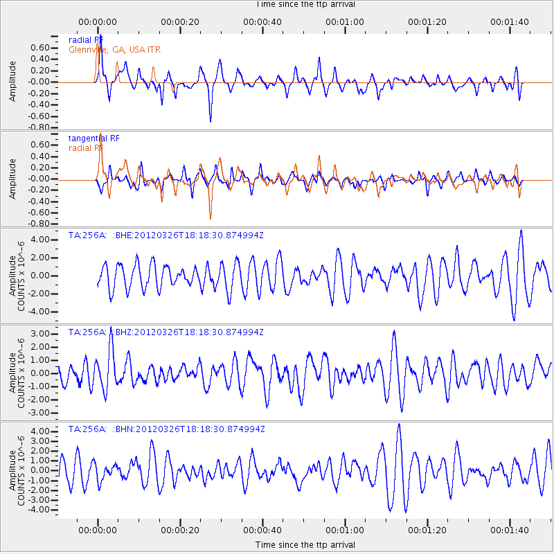
256A Glennville, GA, USA - Earthquake Result Viewer
*The percent match for this event was below the threshold and hence no stack was calculated.
| Earthquake location: |
Northern East Pacific Rise |
| Earthquake latitude/longitude: |
10.1/-104.2 |
| Earthquake time(UTC): |
2012/03/26 (086) 18:12:52 GMT |
| Earthquake Depth: |
10 km |
| Earthquake Magnitude: |
5.6 MB, 5.8 MS, 6.0 MW, 6.0 MW |
| Earthquake Catalog/Contributor: |
WHDF/NEIC |
|
| Network: |
TA USArray Transportable Network (new EarthScope stations) |
| Station: |
256A Glennville, GA, USA |
| Lat/Lon: |
31.98 N/81.89 W |
| Elevation: |
46 m |
|
| Distance: |
30.0 deg |
| Az: |
40.105 deg |
| Baz: |
228.289 deg |
| Ray Param: |
$rayparam |
*The percent match for this event was below the threshold and hence was not used in the summary stack. |
|
| Radial Match: |
69.2394 % |
| Radial Bump: |
383 |
| Transverse Match: |
56.24797 % |
| Transverse Bump: |
305 |
| SOD ConfigId: |
440406 |
| Insert Time: |
2012-06-08 07:12:54.176 +0000 |
| GWidth: |
2.5 |
| Max Bumps: |
400 |
| Tol: |
0.001 |
|
Signal To Noise
| Channel | StoN | STA | LTA |
| TA:256A: :BHZ:20120326T18:18:30.874994Z | 2.7499197 | 1.5160297E-6 | 5.5129965E-7 |
| TA:256A: :BHN:20120326T18:18:30.874994Z | 0.8093134 | 8.268346E-7 | 1.0216495E-6 |
| TA:256A: :BHE:20120326T18:18:30.874994Z | 1.3089217 | 1.5925255E-6 | 1.2166697E-6 |
| Arrivals |
| Ps | |
| PpPs | |
| PsPs/PpSs | |


