You are here: Home > Network List > G - GEOSCOPE Stations List
> Station INU Inuyama, Japan > Earthquake Result Viewer
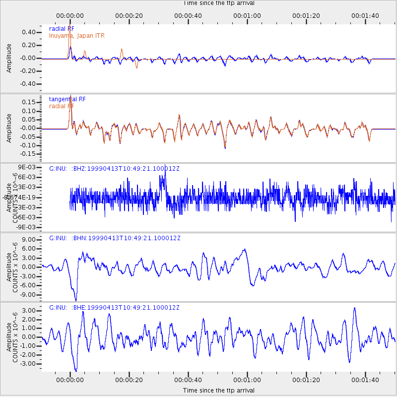
INU Inuyama, Japan - Earthquake Result Viewer
*The percent match for this event was below the threshold and hence no stack was calculated.
| Earthquake location: |
Fiji Islands Region |
| Earthquake latitude/longitude: |
-21.4/-176.5 |
| Earthquake time(UTC): |
1999/04/13 (103) 10:38:48 GMT |
| Earthquake Depth: |
164 km |
| Earthquake Magnitude: |
6.4 MB, 6.8 MW, 6.8 MW |
| Earthquake Catalog/Contributor: |
WHDF/NEIC |
|
| Network: |
G GEOSCOPE |
| Station: |
INU Inuyama, Japan |
| Lat/Lon: |
35.35 N/137.03 E |
| Elevation: |
132 m |
|
| Distance: |
71.6 deg |
| Az: |
321.326 deg |
| Baz: |
134.581 deg |
| Ray Param: |
$rayparam |
*The percent match for this event was below the threshold and hence was not used in the summary stack. |
|
| Radial Match: |
51.84732 % |
| Radial Bump: |
400 |
| Transverse Match: |
51.808094 % |
| Transverse Bump: |
400 |
| SOD ConfigId: |
4480 |
| Insert Time: |
2010-02-26 23:24:57.181 +0000 |
| GWidth: |
2.5 |
| Max Bumps: |
400 |
| Tol: |
0.001 |
|
Signal To Noise
| Channel | StoN | STA | LTA |
| G:INU: :BHN:19990413T10:49:21.100012Z | 6.012181 | 5.561477E-6 | 9.250349E-7 |
| G:INU: :BHE:19990413T10:49:21.100012Z | 1.9856874 | 2.140796E-6 | 1.0781133E-6 |
| G:INU: :BHZ:19990413T10:49:21.100012Z | 1.8736552 | 3.5529435E-9 | 1.8962631E-9 |
| Arrivals |
| Ps | |
| PpPs | |
| PsPs/PpSs | |


