You are here: Home > Network List > G - GEOSCOPE Stations List
> Station INU Inuyama, Japan > Earthquake Result Viewer
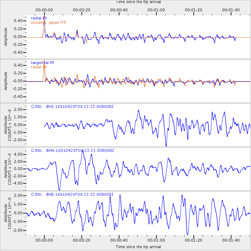
INU Inuyama, Japan - Earthquake Result Viewer
*The percent match for this event was below the threshold and hence no stack was calculated.
| Earthquake location: |
Northwestern Caucasus |
| Earthquake latitude/longitude: |
42.5/43.6 |
| Earthquake time(UTC): |
1991/04/29 (119) 09:12:47 GMT |
| Earthquake Depth: |
10 km |
| Earthquake Magnitude: |
6.2 MB, 7.0 MS |
| Earthquake Catalog/Contributor: |
WHDF/NEIC |
|
| Network: |
G GEOSCOPE |
| Station: |
INU Inuyama, Japan |
| Lat/Lon: |
35.35 N/137.03 E |
| Elevation: |
132 m |
|
| Distance: |
69.4 deg |
| Az: |
60.671 deg |
| Baz: |
307.922 deg |
| Ray Param: |
$rayparam |
*The percent match for this event was below the threshold and hence was not used in the summary stack. |
|
| Radial Match: |
79.88271 % |
| Radial Bump: |
400 |
| Transverse Match: |
75.80747 % |
| Transverse Bump: |
400 |
| SOD ConfigId: |
4480 |
| Insert Time: |
2010-02-26 23:24:57.730 +0000 |
| GWidth: |
2.5 |
| Max Bumps: |
400 |
| Tol: |
0.001 |
|
Signal To Noise
| Channel | StoN | STA | LTA |
| G:INU: :BHN:19910429T09:23:23.908008Z | 5.3615484 | 1.0509956E-6 | 1.9602464E-7 |
| G:INU: :BHE:19910429T09:23:23.908008Z | 1.7503686 | 3.868685E-7 | 2.2102115E-7 |
| G:INU: :BHZ:19910429T09:23:23.908008Z | 1.9581443 | 3.9557304E-7 | 2.0201425E-7 |
| Arrivals |
| Ps | |
| PpPs | |
| PsPs/PpSs | |


